You are here: Home > Network List > II - Global Seismograph Network (GSN - IRIS/IDA) Stations List
> Station WRAB Tennant Creek, NT, Australia > Earthquake Result Viewer
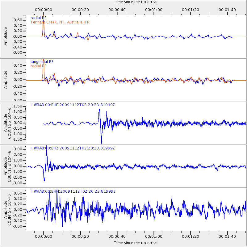
WRAB Tennant Creek, NT, Australia - Earthquake Result Viewer
*The percent match for this event was below the threshold and hence no stack was calculated.
| Earthquake location: |
Fiji Islands Region |
| Earthquake latitude/longitude: |
-21.0/-178.7 |
| Earthquake time(UTC): |
2009/11/12 (316) 02:13:37 GMT |
| Earthquake Depth: |
571 km |
| Earthquake Magnitude: |
5.8 MW, 5.2 MB, 5.8 MW |
| Earthquake Catalog/Contributor: |
WHDF/NEIC |
|
| Network: |
II Global Seismograph Network (GSN - IRIS/IDA) |
| Station: |
WRAB Tennant Creek, NT, Australia |
| Lat/Lon: |
19.93 S/134.36 E |
| Elevation: |
366 m |
|
| Distance: |
43.9 deg |
| Az: |
262.689 deg |
| Baz: |
99.863 deg |
| Ray Param: |
$rayparam |
*The percent match for this event was below the threshold and hence was not used in the summary stack. |
|
| Radial Match: |
79.8366 % |
| Radial Bump: |
319 |
| Transverse Match: |
75.468185 % |
| Transverse Bump: |
394 |
| SOD ConfigId: |
1 |
| Insert Time: |
2010-02-19 01:10:27.870 +0000 |
| GWidth: |
2.5 |
| Max Bumps: |
400 |
| Tol: |
0.001 |
|
Signal To Noise
| Channel | StoN | STA | LTA |
| II:WRAB:00:BHZ:20091112T02:20:23.81999Z | 9.802284 | 1.2105097E-6 | 1.2349261E-7 |
| II:WRAB:00:BHN:20091112T02:20:23.81999Z | 2.458064 | 2.2061829E-7 | 8.975286E-8 |
| II:WRAB:00:BHE:20091112T02:20:23.81999Z | 8.110252 | 6.564376E-7 | 8.093923E-8 |
| Arrivals |
| Ps | |
| PpPs | |
| PsPs/PpSs | |


