You are here: Home > Network List > TA - USArray Transportable Network (new EarthScope stations) Stations List
> Station E13A Victor, MT, USA > Earthquake Result Viewer
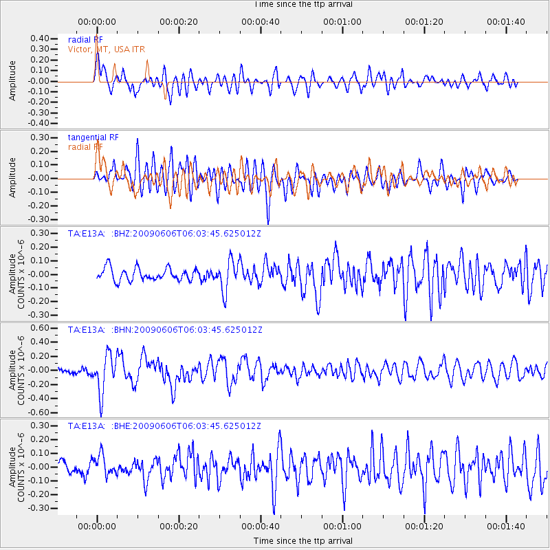
E13A Victor, MT, USA - Earthquake Result Viewer
*The percent match for this event was below the threshold and hence no stack was calculated.
| Earthquake location: |
Near East Coast Of Honshu, Japan |
| Earthquake latitude/longitude: |
35.5/140.9 |
| Earthquake time(UTC): |
2009/06/06 (157) 05:52:43 GMT |
| Earthquake Depth: |
34 km |
| Earthquake Magnitude: |
5.8 MB, 5.4 MS, 5.8 MW, 5.7 MW |
| Earthquake Catalog/Contributor: |
WHDF/NEIC |
|
| Network: |
TA USArray Transportable Network (new EarthScope stations) |
| Station: |
E13A Victor, MT, USA |
| Lat/Lon: |
46.44 N/114.19 W |
| Elevation: |
1257 m |
|
| Distance: |
74.2 deg |
| Az: |
43.989 deg |
| Baz: |
304.948 deg |
| Ray Param: |
$rayparam |
*The percent match for this event was below the threshold and hence was not used in the summary stack. |
|
| Radial Match: |
68.21434 % |
| Radial Bump: |
400 |
| Transverse Match: |
69.73071 % |
| Transverse Bump: |
400 |
| SOD ConfigId: |
2648 |
| Insert Time: |
2010-03-06 15:55:40.137 +0000 |
| GWidth: |
2.5 |
| Max Bumps: |
400 |
| Tol: |
0.001 |
|
Signal To Noise
| Channel | StoN | STA | LTA |
| TA:E13A: :BHN:20090606T06:03:45.625012Z | 5.6084967 | 2.753027E-7 | 4.9086722E-8 |
| TA:E13A: :BHE:20090606T06:03:45.625012Z | 1.9411826 | 7.369474E-8 | 3.7963837E-8 |
| TA:E13A: :BHZ:20090606T06:03:45.625012Z | 2.5422075 | 1.1523881E-7 | 4.5330214E-8 |
| Arrivals |
| Ps | |
| PpPs | |
| PsPs/PpSs | |


