You are here: Home > Network List > TA - USArray Transportable Network (new EarthScope stations) Stations List
> Station E13A Victor, MT, USA > Earthquake Result Viewer
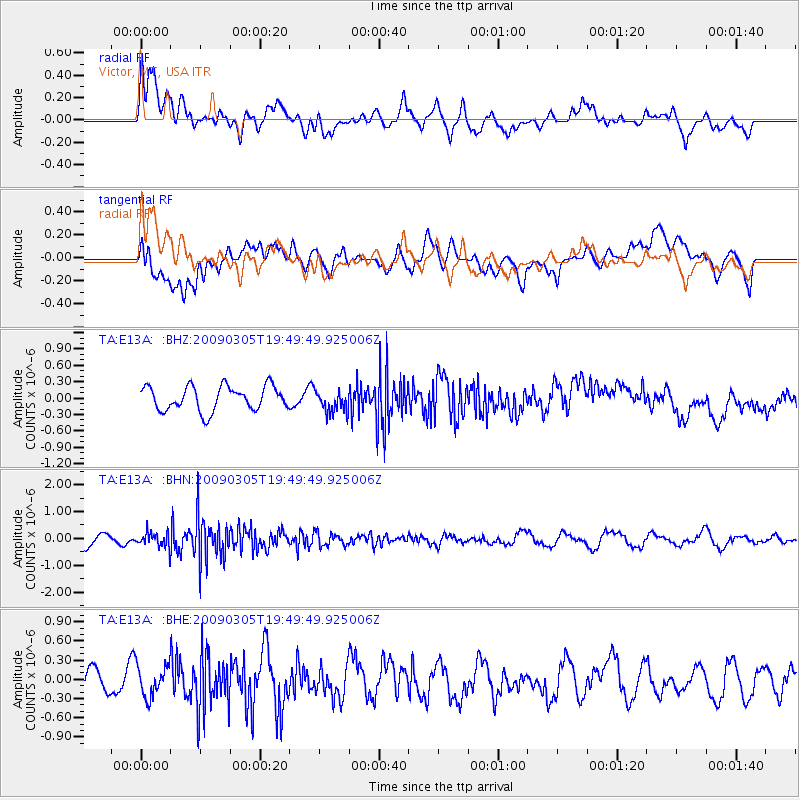
E13A Victor, MT, USA - Earthquake Result Viewer
*The percent match for this event was below the threshold and hence no stack was calculated.
| Earthquake location: |
North Of Svalbard |
| Earthquake latitude/longitude: |
80.3/-1.8 |
| Earthquake time(UTC): |
2009/03/05 (064) 19:41:40 GMT |
| Earthquake Depth: |
10 km |
| Earthquake Magnitude: |
5.5 MB, 5.0 MS, 5.4 MW |
| Earthquake Catalog/Contributor: |
WHDF/NEIC |
|
| Network: |
TA USArray Transportable Network (new EarthScope stations) |
| Station: |
E13A Victor, MT, USA |
| Lat/Lon: |
46.44 N/114.19 W |
| Elevation: |
1257 m |
|
| Distance: |
48.1 deg |
| Az: |
300.844 deg |
| Baz: |
12.175 deg |
| Ray Param: |
$rayparam |
*The percent match for this event was below the threshold and hence was not used in the summary stack. |
|
| Radial Match: |
48.077686 % |
| Radial Bump: |
400 |
| Transverse Match: |
48.08149 % |
| Transverse Bump: |
400 |
| SOD ConfigId: |
2658 |
| Insert Time: |
2010-03-06 15:55:43.077 +0000 |
| GWidth: |
2.5 |
| Max Bumps: |
400 |
| Tol: |
0.001 |
|
Signal To Noise
| Channel | StoN | STA | LTA |
| TA:E13A: :BHN:20090305T19:49:49.925006Z | 1.7225833 | 2.72161E-7 | 1.5799584E-7 |
| TA:E13A: :BHE:20090305T19:49:49.925006Z | 1.5185016 | 2.4044687E-7 | 1.5834482E-7 |
| TA:E13A: :BHZ:20090305T19:49:49.925006Z | 0.92631423 | 2.0687973E-7 | 2.2333644E-7 |
| Arrivals |
| Ps | |
| PpPs | |
| PsPs/PpSs | |


