You are here: Home > Network List > TA - USArray Transportable Network (new EarthScope stations) Stations List
> Station H16K Elim, AK, USA > Earthquake Result Viewer
H16K Elim, AK, USA - Earthquake Result Viewer
*The percent match for this event was below the threshold and hence no stack was calculated.
| Earthquake location: |
Ryukyu Islands, Japan |
| Earthquake latitude/longitude: |
26.7/129.6 |
| Earthquake time(UTC): |
2018/09/15 (258) 08:05:29 GMT |
| Earthquake Depth: |
10 km |
| Earthquake Magnitude: |
5.6 Mww |
| Earthquake Catalog/Contributor: |
NEIC PDE/us |
|
| Network: |
TA USArray Transportable Network (new EarthScope stations) |
| Station: |
H16K Elim, AK, USA |
| Lat/Lon: |
64.64 N/162.24 W |
| Elevation: |
216 m |
|
| Distance: |
56.9 deg |
| Az: |
28.507 deg |
| Baz: |
262.61 deg |
| Ray Param: |
$rayparam |
*The percent match for this event was below the threshold and hence was not used in the summary stack. |
|
| Radial Match: |
66.558495 % |
| Radial Bump: |
400 |
| Transverse Match: |
51.591778 % |
| Transverse Bump: |
400 |
| SOD ConfigId: |
13570011 |
| Insert Time: |
2019-05-01 06:23:03.622 +0000 |
| GWidth: |
2.5 |
| Max Bumps: |
400 |
| Tol: |
0.001 |
|
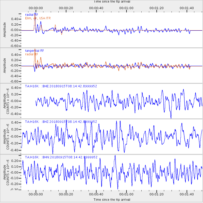
Signal To Noise
| Channel | StoN | STA | LTA |
| TA:H16K: :BHZ:20180915T08:14:42.899995Z | 1.3214123 | 1.4946156E-7 | 1.1310743E-7 |
| TA:H16K: :BHN:20180915T08:14:42.899995Z | 1.0623906 | 9.385056E-8 | 8.8339036E-8 |
| TA:H16K: :BHE:20180915T08:14:42.899995Z | 1.9880204 | 2.0220537E-7 | 1.0171192E-7 |
| Arrivals |
| Ps | |
| PpPs | |
| PsPs/PpSs | |


