You are here: Home > Network List > TA - USArray Transportable Network (new EarthScope stations) Stations List
> Station P17K Kvichak River, AK, USA > Earthquake Result Viewer
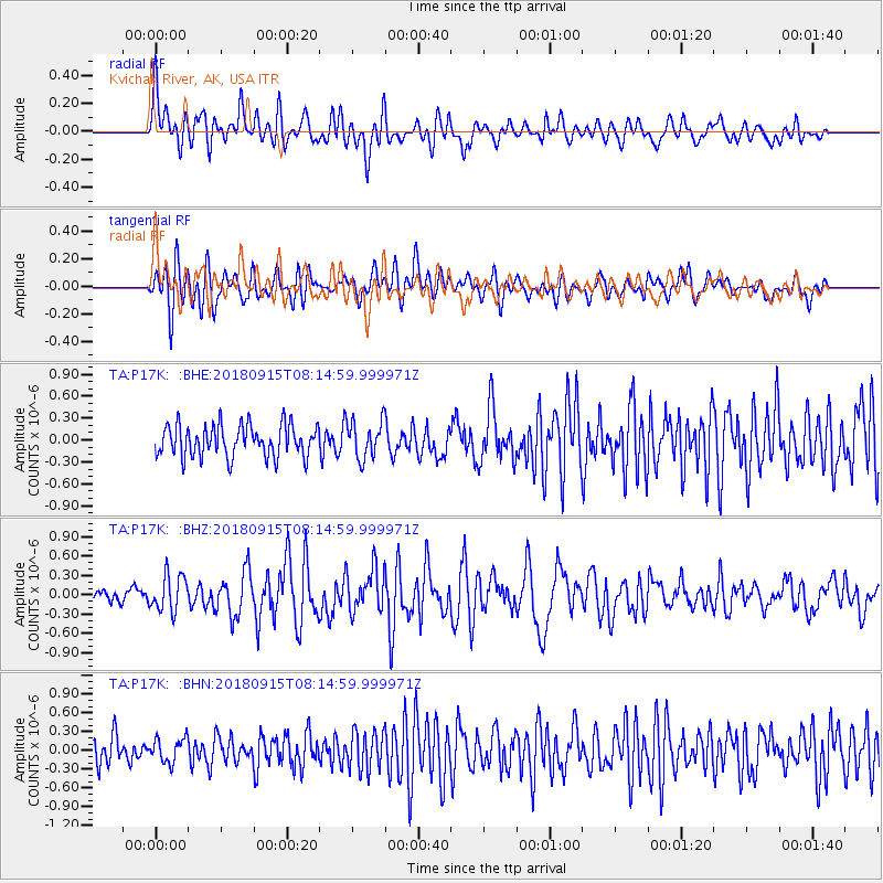
P17K Kvichak River, AK, USA - Earthquake Result Viewer
*The percent match for this event was below the threshold and hence no stack was calculated.
| Earthquake location: |
Ryukyu Islands, Japan |
| Earthquake latitude/longitude: |
26.7/129.6 |
| Earthquake time(UTC): |
2018/09/15 (258) 08:05:29 GMT |
| Earthquake Depth: |
10 km |
| Earthquake Magnitude: |
5.6 Mww |
| Earthquake Catalog/Contributor: |
NEIC PDE/us |
|
| Network: |
TA USArray Transportable Network (new EarthScope stations) |
| Station: |
P17K Kvichak River, AK, USA |
| Lat/Lon: |
59.20 N/156.44 W |
| Elevation: |
91 m |
|
| Distance: |
59.4 deg |
| Az: |
35.097 deg |
| Baz: |
271.208 deg |
| Ray Param: |
$rayparam |
*The percent match for this event was below the threshold and hence was not used in the summary stack. |
|
| Radial Match: |
70.22599 % |
| Radial Bump: |
400 |
| Transverse Match: |
65.869514 % |
| Transverse Bump: |
400 |
| SOD ConfigId: |
13570011 |
| Insert Time: |
2019-05-01 06:23:22.109 +0000 |
| GWidth: |
2.5 |
| Max Bumps: |
400 |
| Tol: |
0.001 |
|
Signal To Noise
| Channel | StoN | STA | LTA |
| TA:P17K: :BHZ:20180915T08:14:59.999971Z | 2.5064762 | 2.8215084E-7 | 1.12568735E-7 |
| TA:P17K: :BHN:20180915T08:14:59.999971Z | 0.82261217 | 1.9134761E-7 | 2.3260976E-7 |
| TA:P17K: :BHE:20180915T08:14:59.999971Z | 1.2197554 | 2.6133822E-7 | 2.1425461E-7 |
| Arrivals |
| Ps | |
| PpPs | |
| PsPs/PpSs | |


