You are here: Home > Network List > TA - USArray Transportable Network (new EarthScope stations) Stations List
> Station E13A Victor, MT, USA > Earthquake Result Viewer
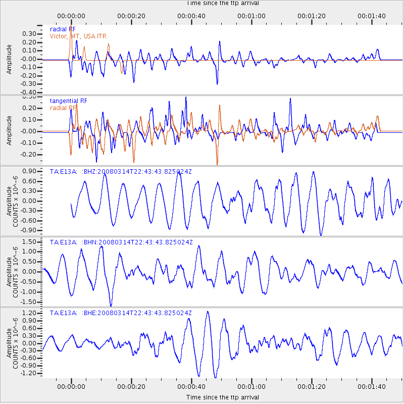
E13A Victor, MT, USA - Earthquake Result Viewer
*The percent match for this event was below the threshold and hence no stack was calculated.
| Earthquake location: |
Bonin Islands, Japan Region |
| Earthquake latitude/longitude: |
27.0/142.6 |
| Earthquake time(UTC): |
2008/03/14 (074) 22:32:09 GMT |
| Earthquake Depth: |
11 km |
| Earthquake Magnitude: |
5.7 MB, 5.9 MS, 6.0 MW, 6.0 MW |
| Earthquake Catalog/Contributor: |
WHDF/NEIC |
|
| Network: |
TA USArray Transportable Network (new EarthScope stations) |
| Station: |
E13A Victor, MT, USA |
| Lat/Lon: |
46.44 N/114.19 W |
| Elevation: |
1257 m |
|
| Distance: |
79.3 deg |
| Az: |
43.238 deg |
| Baz: |
297.875 deg |
| Ray Param: |
$rayparam |
*The percent match for this event was below the threshold and hence was not used in the summary stack. |
|
| Radial Match: |
59.748657 % |
| Radial Bump: |
400 |
| Transverse Match: |
75.079124 % |
| Transverse Bump: |
400 |
| SOD ConfigId: |
2504 |
| Insert Time: |
2010-03-06 15:56:02.358 +0000 |
| GWidth: |
2.5 |
| Max Bumps: |
400 |
| Tol: |
0.001 |
|
Signal To Noise
| Channel | StoN | STA | LTA |
| TA:E13A: :BHN:20080314T22:43:43.825024Z | 4.054402 | 8.169244E-7 | 2.0149072E-7 |
| TA:E13A: :BHE:20080314T22:43:43.825024Z | 0.6129857 | 1.9030102E-7 | 3.1044937E-7 |
| TA:E13A: :BHZ:20080314T22:43:43.825024Z | 1.2693431 | 5.072192E-7 | 3.995919E-7 |
| Arrivals |
| Ps | |
| PpPs | |
| PsPs/PpSs | |


