You are here: Home > Network List > TA - USArray Transportable Network (new EarthScope stations) Stations List
> Station E13A Victor, MT, USA > Earthquake Result Viewer
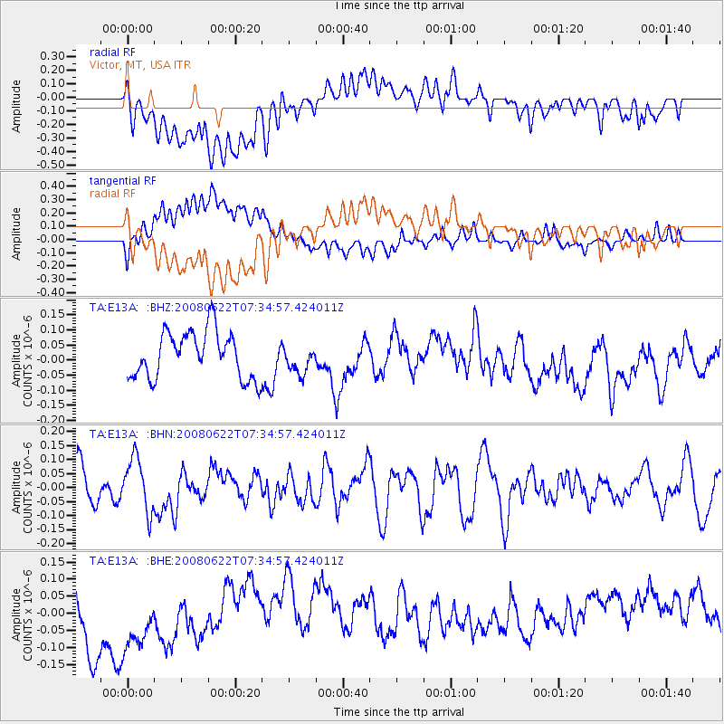
E13A Victor, MT, USA - Earthquake Result Viewer
*The percent match for this event was below the threshold and hence no stack was calculated.
| Earthquake location: |
Solomon Islands |
| Earthquake latitude/longitude: |
-8.9/157.8 |
| Earthquake time(UTC): |
2008/06/22 (174) 07:22:06 GMT |
| Earthquake Depth: |
10 km |
| Earthquake Magnitude: |
5.5 MB, 5.5 MS, 5.8 MW, 5.7 MW |
| Earthquake Catalog/Contributor: |
WHDF/NEIC |
|
| Network: |
TA USArray Transportable Network (new EarthScope stations) |
| Station: |
E13A Victor, MT, USA |
| Lat/Lon: |
46.44 N/114.19 W |
| Elevation: |
1257 m |
|
| Distance: |
95.0 deg |
| Az: |
43.925 deg |
| Baz: |
262.463 deg |
| Ray Param: |
$rayparam |
*The percent match for this event was below the threshold and hence was not used in the summary stack. |
|
| Radial Match: |
34.076744 % |
| Radial Bump: |
400 |
| Transverse Match: |
34.193306 % |
| Transverse Bump: |
400 |
| SOD ConfigId: |
2504 |
| Insert Time: |
2010-03-06 15:56:26.492 +0000 |
| GWidth: |
2.5 |
| Max Bumps: |
400 |
| Tol: |
0.001 |
|
Signal To Noise
| Channel | StoN | STA | LTA |
| TA:E13A: :BHN:20080622T07:34:57.424011Z | 1.81188 | 9.6765696E-8 | 5.3406236E-8 |
| TA:E13A: :BHE:20080622T07:34:57.424011Z | 1.4953068 | 1.3082149E-7 | 8.7488054E-8 |
| TA:E13A: :BHZ:20080622T07:34:57.424011Z | 0.6043705 | 4.6826056E-8 | 7.747906E-8 |
| Arrivals |
| Ps | |
| PpPs | |
| PsPs/PpSs | |


