You are here: Home > Network List > TA - USArray Transportable Network (new EarthScope stations) Stations List
> Station I30M Mount Dempster, Yukon, CAN > Earthquake Result Viewer
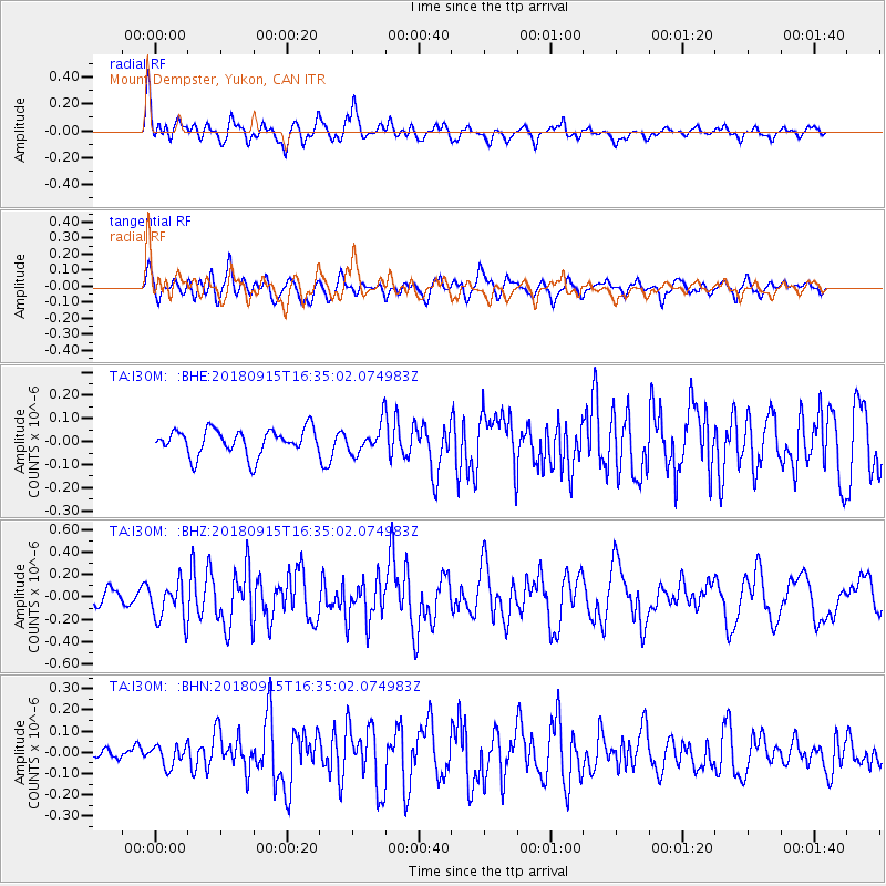
I30M Mount Dempster, Yukon, CAN - Earthquake Result Viewer
*The percent match for this event was below the threshold and hence no stack was calculated.
| Earthquake location: |
Ryukyu Islands, Japan |
| Earthquake latitude/longitude: |
26.6/129.5 |
| Earthquake time(UTC): |
2018/09/15 (258) 16:24:35 GMT |
| Earthquake Depth: |
10 km |
| Earthquake Magnitude: |
5.5 Mww |
| Earthquake Catalog/Contributor: |
NEIC PDE/us |
|
| Network: |
TA USArray Transportable Network (new EarthScope stations) |
| Station: |
I30M Mount Dempster, Yukon, CAN |
| Lat/Lon: |
65.22 N/136.38 W |
| Elevation: |
1399 m |
|
| Distance: |
67.9 deg |
| Az: |
26.982 deg |
| Baz: |
285.368 deg |
| Ray Param: |
$rayparam |
*The percent match for this event was below the threshold and hence was not used in the summary stack. |
|
| Radial Match: |
72.06344 % |
| Radial Bump: |
400 |
| Transverse Match: |
61.372807 % |
| Transverse Bump: |
400 |
| SOD ConfigId: |
13570011 |
| Insert Time: |
2019-05-01 06:29:41.823 +0000 |
| GWidth: |
2.5 |
| Max Bumps: |
400 |
| Tol: |
0.001 |
|
Signal To Noise
| Channel | StoN | STA | LTA |
| TA:I30M: :BHZ:20180915T16:35:02.074983Z | 2.7694802 | 1.7472567E-7 | 6.308969E-8 |
| TA:I30M: :BHN:20180915T16:35:02.074983Z | 1.0558046 | 4.9784582E-8 | 4.7153215E-8 |
| TA:I30M: :BHE:20180915T16:35:02.074983Z | 1.2672784 | 7.54113E-8 | 5.95065E-8 |
| Arrivals |
| Ps | |
| PpPs | |
| PsPs/PpSs | |


