You are here: Home > Network List > TA - USArray Transportable Network (new EarthScope stations) Stations List
> Station E13A Victor, MT, USA > Earthquake Result Viewer
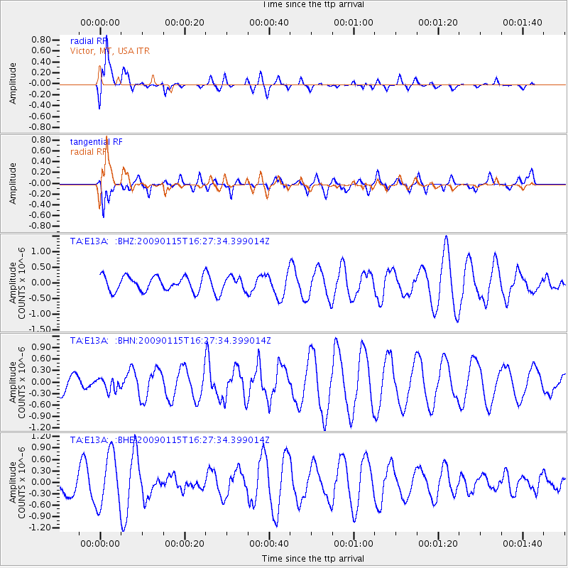
E13A Victor, MT, USA - Earthquake Result Viewer
*The percent match for this event was below the threshold and hence no stack was calculated.
| Earthquake location: |
Solomon Islands |
| Earthquake latitude/longitude: |
-10.3/161.2 |
| Earthquake time(UTC): |
2009/01/15 (015) 16:15:01 GMT |
| Earthquake Depth: |
114 km |
| Earthquake Magnitude: |
5.6 MB, 5.7 MW, 5.7 MW |
| Earthquake Catalog/Contributor: |
WHDF/NEIC |
|
| Network: |
TA USArray Transportable Network (new EarthScope stations) |
| Station: |
E13A Victor, MT, USA |
| Lat/Lon: |
46.44 N/114.19 W |
| Elevation: |
1257 m |
|
| Distance: |
93.7 deg |
| Az: |
43.621 deg |
| Baz: |
259.017 deg |
| Ray Param: |
$rayparam |
*The percent match for this event was below the threshold and hence was not used in the summary stack. |
|
| Radial Match: |
76.12052 % |
| Radial Bump: |
400 |
| Transverse Match: |
50.433266 % |
| Transverse Bump: |
400 |
| SOD ConfigId: |
2834 |
| Insert Time: |
2010-03-06 15:56:49.098 +0000 |
| GWidth: |
2.5 |
| Max Bumps: |
400 |
| Tol: |
0.001 |
|
Signal To Noise
| Channel | StoN | STA | LTA |
| TA:E13A: :BHN:20090115T16:27:34.399014Z | 0.54237735 | 1.655884E-7 | 3.053011E-7 |
| TA:E13A: :BHE:20090115T16:27:34.399014Z | 1.8965311 | 7.0424846E-7 | 3.7133506E-7 |
| TA:E13A: :BHZ:20090115T16:27:34.399014Z | 0.87926596 | 2.0239544E-7 | 2.3018683E-7 |
| Arrivals |
| Ps | |
| PpPs | |
| PsPs/PpSs | |


