You are here: Home > Network List > TA - USArray Transportable Network (new EarthScope stations) Stations List
> Station E13A Victor, MT, USA > Earthquake Result Viewer
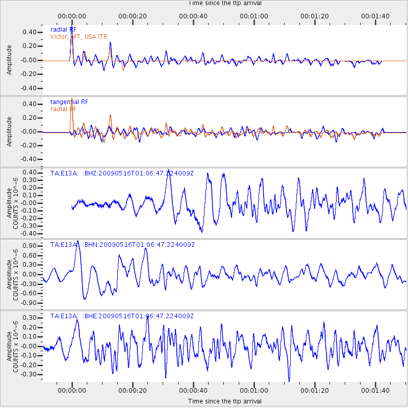
E13A Victor, MT, USA - Earthquake Result Viewer
*The percent match for this event was below the threshold and hence no stack was calculated.
| Earthquake location: |
Kermadec Islands Region |
| Earthquake latitude/longitude: |
-31.5/-178.8 |
| Earthquake time(UTC): |
2009/05/16 (136) 00:53:52 GMT |
| Earthquake Depth: |
55 km |
| Earthquake Magnitude: |
6.1 MB, 6.5 MW, 6.3 MW |
| Earthquake Catalog/Contributor: |
WHDF/NEIC |
|
| Network: |
TA USArray Transportable Network (new EarthScope stations) |
| Station: |
E13A Victor, MT, USA |
| Lat/Lon: |
46.44 N/114.19 W |
| Elevation: |
1257 m |
|
| Distance: |
97.0 deg |
| Az: |
39.008 deg |
| Baz: |
231.019 deg |
| Ray Param: |
$rayparam |
*The percent match for this event was below the threshold and hence was not used in the summary stack. |
|
| Radial Match: |
76.88492 % |
| Radial Bump: |
400 |
| Transverse Match: |
73.8034 % |
| Transverse Bump: |
400 |
| SOD ConfigId: |
2760 |
| Insert Time: |
2010-03-06 15:56:53.161 +0000 |
| GWidth: |
2.5 |
| Max Bumps: |
400 |
| Tol: |
0.001 |
|
Signal To Noise
| Channel | StoN | STA | LTA |
| TA:E13A: :BHN:20090516T01:06:47.224009Z | 4.605229 | 6.1676013E-7 | 1.3392605E-7 |
| TA:E13A: :BHE:20090516T01:06:47.224009Z | 2.5094175 | 1.516749E-7 | 6.0442275E-8 |
| TA:E13A: :BHZ:20090516T01:06:47.224009Z | 4.523135 | 2.2774587E-7 | 5.035133E-8 |
| Arrivals |
| Ps | |
| PpPs | |
| PsPs/PpSs | |


