You are here: Home > Network List > US - United States National Seismic Network Stations List
> Station AMTX Amarillo, Texas, USA > Earthquake Result Viewer
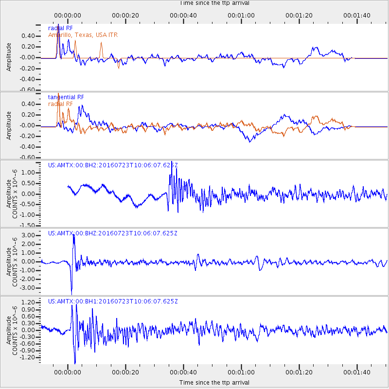
AMTX Amarillo, Texas, USA - Earthquake Result Viewer
*The percent match for this event was below the threshold and hence no stack was calculated.
| Earthquake location: |
Alaska Peninsula |
| Earthquake latitude/longitude: |
58.6/-156.6 |
| Earthquake time(UTC): |
2016/07/23 (205) 09:59:00 GMT |
| Earthquake Depth: |
204 km |
| Earthquake Magnitude: |
5.7 MB, 5.1 MI, 5.4 ML |
| Earthquake Catalog/Contributor: |
NEIC PDE/NEIC COMCAT |
|
| Network: |
US United States National Seismic Network |
| Station: |
AMTX Amarillo, Texas, USA |
| Lat/Lon: |
34.53 N/101.41 W |
| Elevation: |
1010 m |
|
| Distance: |
43.3 deg |
| Az: |
98.891 deg |
| Baz: |
321.15 deg |
| Ray Param: |
$rayparam |
*The percent match for this event was below the threshold and hence was not used in the summary stack. |
|
| Radial Match: |
55.452652 % |
| Radial Bump: |
400 |
| Transverse Match: |
36.77421 % |
| Transverse Bump: |
400 |
| SOD ConfigId: |
1634031 |
| Insert Time: |
2016-08-06 10:18:12.598 +0000 |
| GWidth: |
2.5 |
| Max Bumps: |
400 |
| Tol: |
0.001 |
|
Signal To Noise
| Channel | StoN | STA | LTA |
| US:AMTX:00:BHZ:20160723T10:06:07.625Z | 15.157067 | 1.3426484E-6 | 8.858233E-8 |
| US:AMTX:00:BH1:20160723T10:06:07.625Z | 5.6626825 | 6.094449E-7 | 1.07624764E-7 |
| US:AMTX:00:BH2:20160723T10:06:07.625Z | 1.7042696 | 5.28992E-7 | 3.1039218E-7 |
| Arrivals |
| Ps | |
| PpPs | |
| PsPs/PpSs | |


