You are here: Home > Network List > TA - USArray Transportable Network (new EarthScope stations) Stations List
> Station T28A Walsh, CO, USA > Earthquake Result Viewer
T28A Walsh, CO, USA - Earthquake Result Viewer
| Earthquake location: |
Southeast Of Honshu, Japan |
| Earthquake latitude/longitude: |
32.8/140.4 |
| Earthquake time(UTC): |
2009/08/12 (224) 22:48:51 GMT |
| Earthquake Depth: |
53 km |
| Earthquake Magnitude: |
6.2 MB, 6.6 MW, 6.6 MW |
| Earthquake Catalog/Contributor: |
WHDF/NEIC |
|
| Network: |
TA USArray Transportable Network (new EarthScope stations) |
| Station: |
T28A Walsh, CO, USA |
| Lat/Lon: |
37.12 N/102.11 W |
| Elevation: |
1148 m |
|
| Distance: |
89.2 deg |
| Az: |
45.163 deg |
| Baz: |
311.668 deg |
| Ray Param: |
0.041915786 |
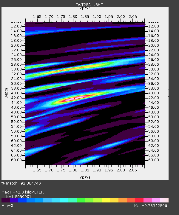
| Estimated Moho Depth: |
42.0 km |
| Estimated Crust Vp/Vs: |
1.81 |
| Assumed Crust Vp: |
6.306 km/s |
| Estimated Crust Vs: |
3.494 km/s |
| Estimated Crust Poisson's Ratio: |
0.28 |
|
| Radial Match: |
92.864746 % |
| Radial Bump: |
400 |
| Transverse Match: |
71.97741 % |
| Transverse Bump: |
400 |
| SOD ConfigId: |
2622 |
| Insert Time: |
2010-03-06 15:57:04.805 +0000 |
| GWidth: |
2.5 |
| Max Bumps: |
400 |
| Tol: |
0.001 |
|
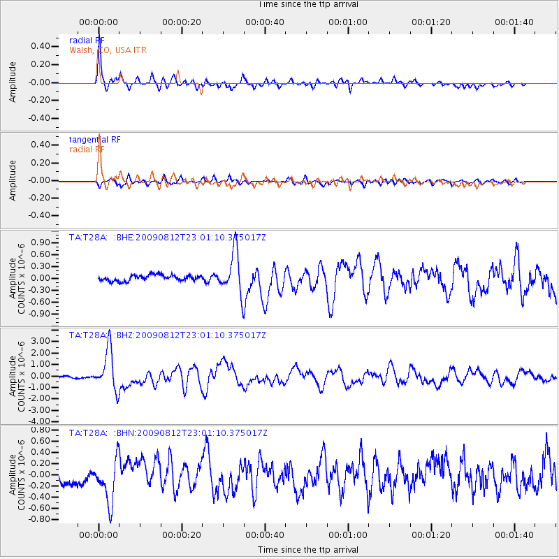
Signal To Noise
| Channel | StoN | STA | LTA |
| TA:T28A: :BHZ:20090812T23:01:10.375017Z | 26.344505 | 1.8320563E-6 | 6.954226E-8 |
| TA:T28A: :BHN:20090812T23:01:10.375017Z | 3.5716138 | 4.0239996E-7 | 1.1266614E-7 |
| TA:T28A: :BHE:20090812T23:01:10.375017Z | 7.5681467 | 5.495575E-7 | 7.261454E-8 |
| Arrivals |
| Ps | 5.5 SECOND |
| PpPs | 18 SECOND |
| PsPs/PpSs | 24 SECOND |


