You are here: Home > Network List > AV - Alaska Volcano Observatory Stations List
> Station SPBL Spurr Beluga Lake, Mount Spur, Alaska > Earthquake Result Viewer
SPBL Spurr Beluga Lake, Mount Spur, Alaska - Earthquake Result Viewer
| Earthquake location: |
South Of Fiji Islands |
| Earthquake latitude/longitude: |
-25.5/178.2 |
| Earthquake time(UTC): |
2018/09/16 (259) 21:11:48 GMT |
| Earthquake Depth: |
570 km |
| Earthquake Magnitude: |
6.5 Mww |
| Earthquake Catalog/Contributor: |
NEIC PDE/us |
|
| Network: |
AV Alaska Volcano Observatory |
| Station: |
SPBL Spurr Beluga Lake, Mount Spur, Alaska |
| Lat/Lon: |
61.38 N/151.89 W |
| Elevation: |
927 m |
|
| Distance: |
89.8 deg |
| Az: |
13.883 deg |
| Baz: |
206.773 deg |
| Ray Param: |
0.041523457 |
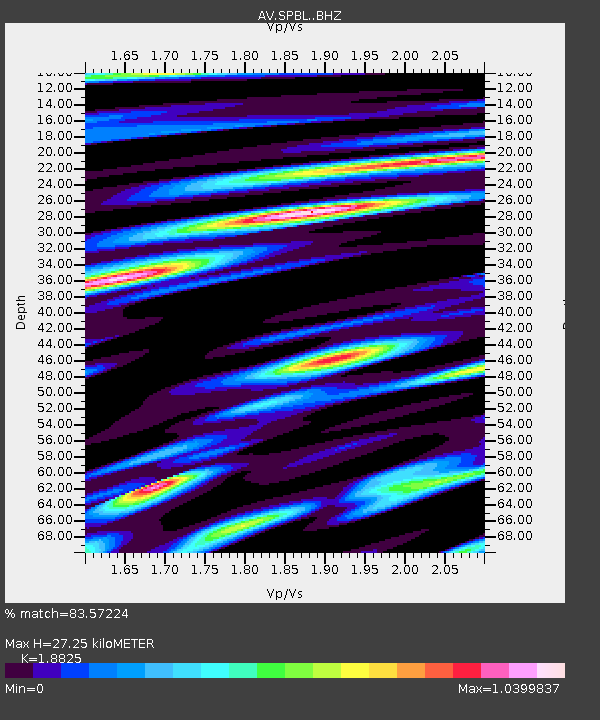
| Estimated Moho Depth: |
27.25 km |
| Estimated Crust Vp/Vs: |
1.88 |
| Assumed Crust Vp: |
6.302 km/s |
| Estimated Crust Vs: |
3.347 km/s |
| Estimated Crust Poisson's Ratio: |
0.30 |
|
| Radial Match: |
83.57224 % |
| Radial Bump: |
400 |
| Transverse Match: |
68.29577 % |
| Transverse Bump: |
400 |
| SOD ConfigId: |
13570011 |
| Insert Time: |
2019-05-01 06:33:21.566 +0000 |
| GWidth: |
2.5 |
| Max Bumps: |
400 |
| Tol: |
0.001 |
|

Signal To Noise
| Channel | StoN | STA | LTA |
| AV:SPBL: :BHZ:20180916T21:23:15.319995Z | 18.20575 | 8.754565E-7 | 4.8086818E-8 |
| AV:SPBL: :BHN:20180916T21:23:15.319995Z | 5.228025 | 2.522851E-7 | 4.8256293E-8 |
| AV:SPBL: :BHE:20180916T21:23:15.319995Z | 3.9796085 | 1.8923552E-7 | 4.7551293E-8 |
| Arrivals |
| Ps | 3.9 SECOND |
| PpPs | 12 SECOND |
| PsPs/PpSs | 16 SECOND |


