You are here: Home > Network List > TA - USArray Transportable Network (new EarthScope stations) Stations List
> Station T28A Walsh, CO, USA > Earthquake Result Viewer
T28A Walsh, CO, USA - Earthquake Result Viewer
| Earthquake location: |
Near Coast Of Venezuela |
| Earthquake latitude/longitude: |
10.7/-67.9 |
| Earthquake time(UTC): |
2009/09/12 (255) 20:06:24 GMT |
| Earthquake Depth: |
10 km |
| Earthquake Magnitude: |
6.3 MB, 6.4 MS, 6.3 MW, 6.3 MW |
| Earthquake Catalog/Contributor: |
WHDF/NEIC |
|
| Network: |
TA USArray Transportable Network (new EarthScope stations) |
| Station: |
T28A Walsh, CO, USA |
| Lat/Lon: |
37.12 N/102.11 W |
| Elevation: |
1148 m |
|
| Distance: |
40.5 deg |
| Az: |
316.209 deg |
| Baz: |
121.689 deg |
| Ray Param: |
0.07438077 |
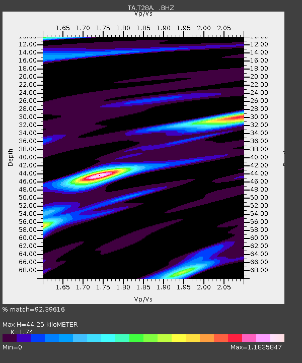
| Estimated Moho Depth: |
44.25 km |
| Estimated Crust Vp/Vs: |
1.74 |
| Assumed Crust Vp: |
6.306 km/s |
| Estimated Crust Vs: |
3.624 km/s |
| Estimated Crust Poisson's Ratio: |
0.25 |
|
| Radial Match: |
92.39616 % |
| Radial Bump: |
230 |
| Transverse Match: |
65.83009 % |
| Transverse Bump: |
400 |
| SOD ConfigId: |
2622 |
| Insert Time: |
2010-03-06 15:57:10.642 +0000 |
| GWidth: |
2.5 |
| Max Bumps: |
400 |
| Tol: |
0.001 |
|
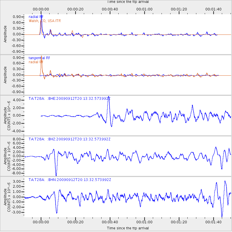
Signal To Noise
| Channel | StoN | STA | LTA |
| TA:T28A: :BHZ:20090912T20:13:32.573992Z | 5.7212934 | 7.726494E-7 | 1.3504803E-7 |
| TA:T28A: :BHN:20090912T20:13:32.573992Z | 2.4332068 | 2.773089E-7 | 1.1396849E-7 |
| TA:T28A: :BHE:20090912T20:13:32.573992Z | 3.2187884 | 3.838294E-7 | 1.1924655E-7 |
| Arrivals |
| Ps | 5.6 SECOND |
| PpPs | 18 SECOND |
| PsPs/PpSs | 24 SECOND |


