You are here: Home > Network List > AZ - ANZA Regional Network Stations List
> Station SMER AZ.SMER > Earthquake Result Viewer
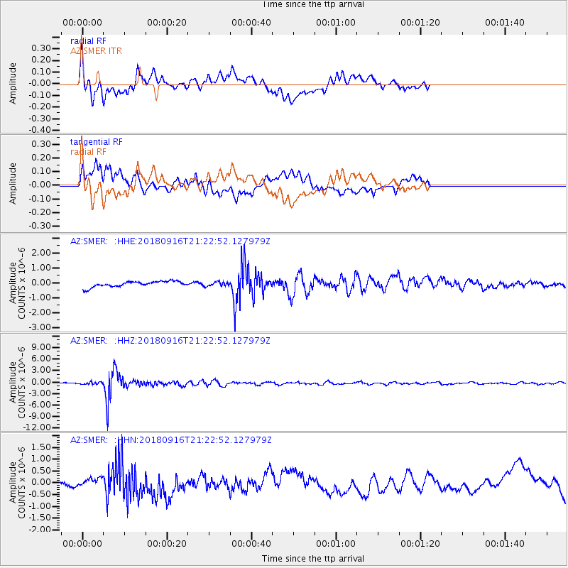
SMER AZ.SMER - Earthquake Result Viewer
*The percent match for this event was below the threshold and hence no stack was calculated.
| Earthquake location: |
South Of Fiji Islands |
| Earthquake latitude/longitude: |
-25.5/178.2 |
| Earthquake time(UTC): |
2018/09/16 (259) 21:11:48 GMT |
| Earthquake Depth: |
570 km |
| Earthquake Magnitude: |
6.5 Mww |
| Earthquake Catalog/Contributor: |
NEIC PDE/us |
|
| Network: |
AZ ANZA Regional Network |
| Station: |
SMER AZ.SMER |
| Lat/Lon: |
33.46 N/117.17 W |
| Elevation: |
355 m |
|
| Distance: |
84.9 deg |
| Az: |
49.313 deg |
| Baz: |
235.087 deg |
| Ray Param: |
$rayparam |
*The percent match for this event was below the threshold and hence was not used in the summary stack. |
|
| Radial Match: |
59.81419 % |
| Radial Bump: |
400 |
| Transverse Match: |
54.85451 % |
| Transverse Bump: |
400 |
| SOD ConfigId: |
13570011 |
| Insert Time: |
2019-05-01 06:33:33.630 +0000 |
| GWidth: |
2.5 |
| Max Bumps: |
400 |
| Tol: |
0.001 |
|
Signal To Noise
| Channel | StoN | STA | LTA |
| AZ:SMER: :HHZ:20180916T21:22:52.127979Z | 3.7699778 | 2.7315713E-7 | 7.245589E-8 |
| AZ:SMER: :HHN:20180916T21:22:52.127979Z | 1.1405739 | 2.2890849E-7 | 2.0069588E-7 |
| AZ:SMER: :HHE:20180916T21:22:52.127979Z | 0.6699636 | 1.2287921E-7 | 1.8341177E-7 |
| Arrivals |
| Ps | |
| PpPs | |
| PsPs/PpSs | |


