You are here: Home > Network List > TA - USArray Transportable Network (new EarthScope stations) Stations List
> Station H16K Elim, AK, USA > Earthquake Result Viewer
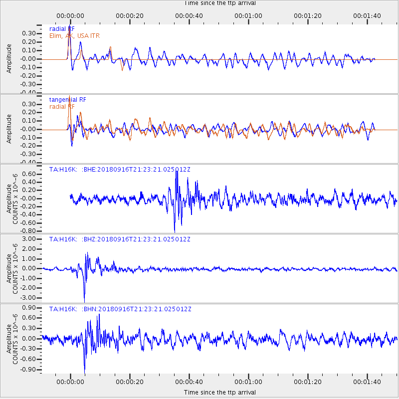
H16K Elim, AK, USA - Earthquake Result Viewer
*The percent match for this event was below the threshold and hence no stack was calculated.
| Earthquake location: |
South Of Fiji Islands |
| Earthquake latitude/longitude: |
-25.5/178.2 |
| Earthquake time(UTC): |
2018/09/16 (259) 21:11:48 GMT |
| Earthquake Depth: |
570 km |
| Earthquake Magnitude: |
6.5 Mww |
| Earthquake Catalog/Contributor: |
NEIC PDE/us |
|
| Network: |
TA USArray Transportable Network (new EarthScope stations) |
| Station: |
H16K Elim, AK, USA |
| Lat/Lon: |
64.64 N/162.24 W |
| Elevation: |
216 m |
|
| Distance: |
91.1 deg |
| Az: |
8.284 deg |
| Baz: |
197.605 deg |
| Ray Param: |
$rayparam |
*The percent match for this event was below the threshold and hence was not used in the summary stack. |
|
| Radial Match: |
78.23983 % |
| Radial Bump: |
400 |
| Transverse Match: |
66.67884 % |
| Transverse Bump: |
400 |
| SOD ConfigId: |
13570011 |
| Insert Time: |
2019-05-01 06:36:49.667 +0000 |
| GWidth: |
2.5 |
| Max Bumps: |
400 |
| Tol: |
0.001 |
|
Signal To Noise
| Channel | StoN | STA | LTA |
| TA:H16K: :BHZ:20180916T21:23:21.025012Z | 12.934393 | 7.789177E-7 | 6.022066E-8 |
| TA:H16K: :BHN:20180916T21:23:21.025012Z | 2.8437774 | 2.1984401E-7 | 7.730704E-8 |
| TA:H16K: :BHE:20180916T21:23:21.025012Z | 2.8206422 | 1.7766729E-7 | 6.298824E-8 |
| Arrivals |
| Ps | |
| PpPs | |
| PsPs/PpSs | |


