You are here: Home > Network List > TA - USArray Transportable Network (new EarthScope stations) Stations List
> Station I17K Unalakleet, AK, USA > Earthquake Result Viewer
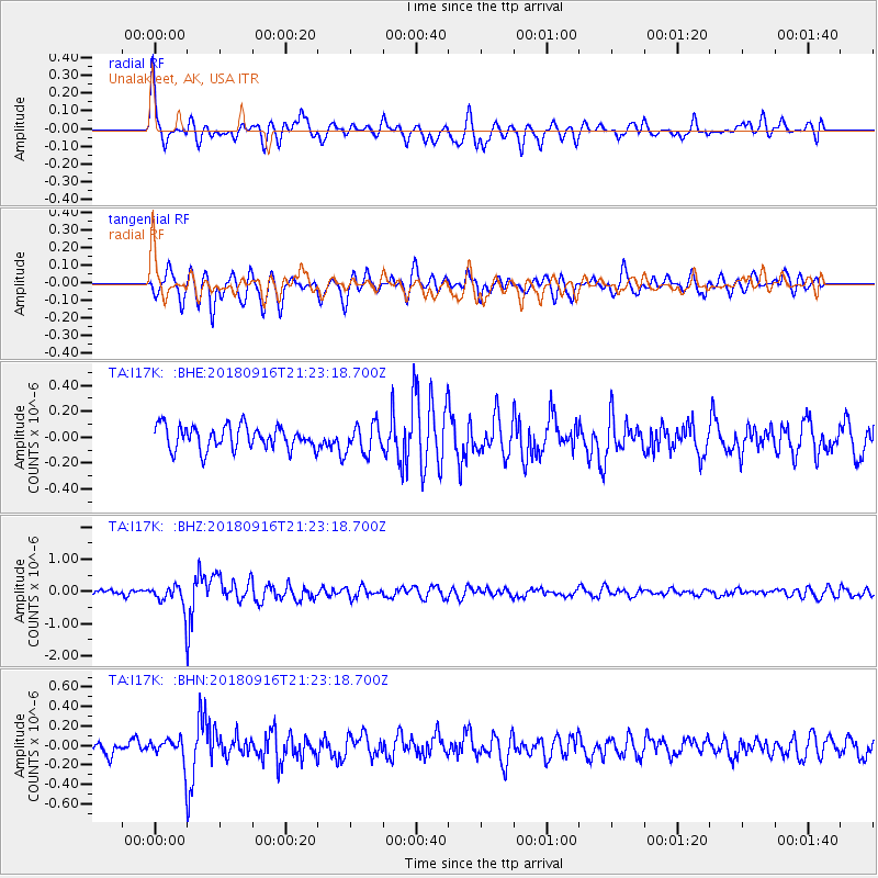
I17K Unalakleet, AK, USA - Earthquake Result Viewer
*The percent match for this event was below the threshold and hence no stack was calculated.
| Earthquake location: |
South Of Fiji Islands |
| Earthquake latitude/longitude: |
-25.5/178.2 |
| Earthquake time(UTC): |
2018/09/16 (259) 21:11:48 GMT |
| Earthquake Depth: |
570 km |
| Earthquake Magnitude: |
6.5 Mww |
| Earthquake Catalog/Contributor: |
NEIC PDE/us |
|
| Network: |
TA USArray Transportable Network (new EarthScope stations) |
| Station: |
I17K Unalakleet, AK, USA |
| Lat/Lon: |
63.89 N/160.70 W |
| Elevation: |
105 m |
|
| Distance: |
90.6 deg |
| Az: |
9.161 deg |
| Baz: |
198.981 deg |
| Ray Param: |
$rayparam |
*The percent match for this event was below the threshold and hence was not used in the summary stack. |
|
| Radial Match: |
70.44535 % |
| Radial Bump: |
400 |
| Transverse Match: |
65.77336 % |
| Transverse Bump: |
400 |
| SOD ConfigId: |
13570011 |
| Insert Time: |
2019-05-01 06:36:55.084 +0000 |
| GWidth: |
2.5 |
| Max Bumps: |
400 |
| Tol: |
0.001 |
|
Signal To Noise
| Channel | StoN | STA | LTA |
| TA:I17K: :BHZ:20180916T21:23:18.700Z | 4.246547 | 3.5507034E-7 | 8.36139E-8 |
| TA:I17K: :BHN:20180916T21:23:18.700Z | 1.2661039 | 1.21856E-7 | 9.624487E-8 |
| TA:I17K: :BHE:20180916T21:23:18.700Z | 1.2103815 | 1.0871668E-7 | 8.9820176E-8 |
| Arrivals |
| Ps | |
| PpPs | |
| PsPs/PpSs | |


