You are here: Home > Network List > TA - USArray Transportable Network (new EarthScope stations) Stations List
> Station T28A Walsh, CO, USA > Earthquake Result Viewer
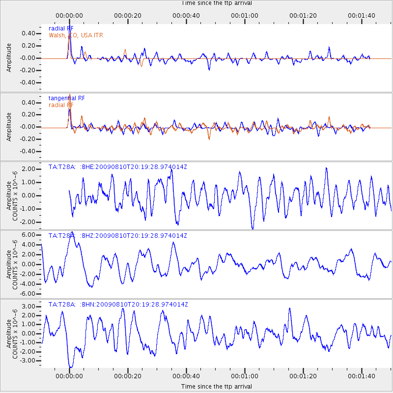
T28A Walsh, CO, USA - Earthquake Result Viewer
*The percent match for this event was below the threshold and hence no stack was calculated.
| Earthquake location: |
Near S. Coast Of Honshu, Japan |
| Earthquake latitude/longitude: |
34.7/138.3 |
| Earthquake time(UTC): |
2009/08/10 (222) 20:07:09 GMT |
| Earthquake Depth: |
40 km |
| Earthquake Magnitude: |
6.1 MB |
| Earthquake Catalog/Contributor: |
WHDF/NEIC |
|
| Network: |
TA USArray Transportable Network (new EarthScope stations) |
| Station: |
T28A Walsh, CO, USA |
| Lat/Lon: |
37.12 N/102.11 W |
| Elevation: |
1148 m |
|
| Distance: |
89.1 deg |
| Az: |
44.022 deg |
| Baz: |
314.278 deg |
| Ray Param: |
$rayparam |
*The percent match for this event was below the threshold and hence was not used in the summary stack. |
|
| Radial Match: |
70.54732 % |
| Radial Bump: |
399 |
| Transverse Match: |
68.35991 % |
| Transverse Bump: |
400 |
| SOD ConfigId: |
2622 |
| Insert Time: |
2010-03-06 15:57:43.132 +0000 |
| GWidth: |
2.5 |
| Max Bumps: |
400 |
| Tol: |
0.001 |
|
Signal To Noise
| Channel | StoN | STA | LTA |
| TA:T28A: :BHZ:20090810T20:19:28.974014Z | 2.5015059 | 4.6423615E-6 | 1.8558268E-6 |
| TA:T28A: :BHN:20090810T20:19:28.974014Z | 2.3179522 | 2.5785869E-6 | 1.1124417E-6 |
| TA:T28A: :BHE:20090810T20:19:28.974014Z | 1.5628366 | 1.0789989E-6 | 6.904106E-7 |
| Arrivals |
| Ps | |
| PpPs | |
| PsPs/PpSs | |


