You are here: Home > Network List > TA - USArray Transportable Network (new EarthScope stations) Stations List
> Station Q18K Katmai Hardscrabble Creek, AK, USA > Earthquake Result Viewer
Q18K Katmai Hardscrabble Creek, AK, USA - Earthquake Result Viewer
| Earthquake location: |
South Of Fiji Islands |
| Earthquake latitude/longitude: |
-25.5/178.2 |
| Earthquake time(UTC): |
2018/09/16 (259) 21:11:48 GMT |
| Earthquake Depth: |
570 km |
| Earthquake Magnitude: |
6.5 Mww |
| Earthquake Catalog/Contributor: |
NEIC PDE/us |
|
| Network: |
TA USArray Transportable Network (new EarthScope stations) |
| Station: |
Q18K Katmai Hardscrabble Creek, AK, USA |
| Lat/Lon: |
58.65 N/155.01 W |
| Elevation: |
1250 m |
|
| Distance: |
86.7 deg |
| Az: |
13.645 deg |
| Baz: |
204.073 deg |
| Ray Param: |
0.042236023 |
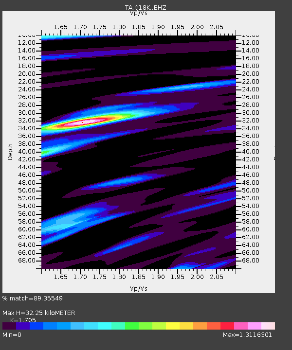
| Estimated Moho Depth: |
32.25 km |
| Estimated Crust Vp/Vs: |
1.71 |
| Assumed Crust Vp: |
6.438 km/s |
| Estimated Crust Vs: |
3.776 km/s |
| Estimated Crust Poisson's Ratio: |
0.24 |
|
| Radial Match: |
89.35549 % |
| Radial Bump: |
400 |
| Transverse Match: |
77.639046 % |
| Transverse Bump: |
400 |
| SOD ConfigId: |
13570011 |
| Insert Time: |
2019-05-01 06:37:59.568 +0000 |
| GWidth: |
2.5 |
| Max Bumps: |
400 |
| Tol: |
0.001 |
|

Signal To Noise
| Channel | StoN | STA | LTA |
| TA:Q18K: :BHZ:20180916T21:23:00.775012Z | 14.417377 | 2.2467518E-6 | 1.5583637E-7 |
| TA:Q18K: :BHN:20180916T21:23:00.775012Z | 6.1897907 | 7.5107937E-7 | 1.2134164E-7 |
| TA:Q18K: :BHE:20180916T21:23:00.775012Z | 2.1208236 | 2.707187E-7 | 1.2764791E-7 |
| Arrivals |
| Ps | 3.6 SECOND |
| PpPs | 13 SECOND |
| PsPs/PpSs | 17 SECOND |


