You are here: Home > Network List > CB - China National Seismic Network Stations List
> Station GOM Geermu,Qinghai Province > Earthquake Result Viewer
GOM Geermu,Qinghai Province - Earthquake Result Viewer
| Earthquake location: |
Southwest Indian Ridge |
| Earthquake latitude/longitude: |
-37.8/49.8 |
| Earthquake time(UTC): |
2018/09/18 (261) 07:27:40 GMT |
| Earthquake Depth: |
10 km |
| Earthquake Magnitude: |
5.8 mb |
| Earthquake Catalog/Contributor: |
NEIC PDE/us |
|
| Network: |
CB China National Seismic Network |
| Station: |
GOM Geermu,Qinghai Province |
| Lat/Lon: |
36.20 N/94.81 E |
| Elevation: |
3121 m |
|
| Distance: |
84.6 deg |
| Az: |
35.095 deg |
| Baz: |
214.265 deg |
| Ray Param: |
0.045352943 |
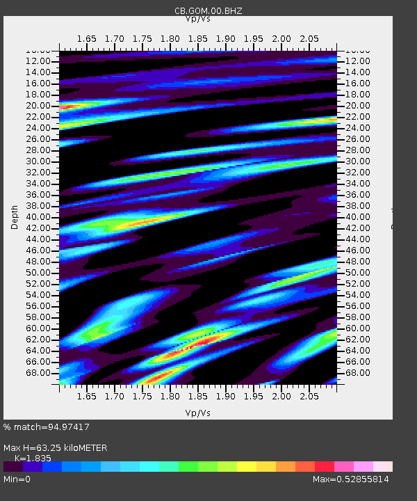
| Estimated Moho Depth: |
63.25 km |
| Estimated Crust Vp/Vs: |
1.84 |
| Assumed Crust Vp: |
6.385 km/s |
| Estimated Crust Vs: |
3.48 km/s |
| Estimated Crust Poisson's Ratio: |
0.29 |
|
| Radial Match: |
94.97417 % |
| Radial Bump: |
400 |
| Transverse Match: |
89.31518 % |
| Transverse Bump: |
400 |
| SOD ConfigId: |
13570011 |
| Insert Time: |
2019-05-01 06:40:39.210 +0000 |
| GWidth: |
2.5 |
| Max Bumps: |
400 |
| Tol: |
0.001 |
|

Signal To Noise
| Channel | StoN | STA | LTA |
| CB:GOM:00:BHZ:20180918T07:39:43.410022Z | 8.186367 | 5.28302E-7 | 6.453436E-8 |
| CB:GOM:00:BHN:20180918T07:39:43.410022Z | 5.9487553 | 1.7426599E-7 | 2.9294531E-8 |
| CB:GOM:00:BHE:20180918T07:39:43.410022Z | 2.2676208 | 7.370257E-8 | 3.250216E-8 |
| Arrivals |
| Ps | 8.5 SECOND |
| PpPs | 27 SECOND |
| PsPs/PpSs | 36 SECOND |


