You are here: Home > Network List > TJ - Tajikistan National Seismic Network Stations List
> Station CHGR Chuyangaron, Tajikistan > Earthquake Result Viewer
CHGR Chuyangaron, Tajikistan - Earthquake Result Viewer
| Earthquake location: |
Southwest Indian Ridge |
| Earthquake latitude/longitude: |
-37.8/49.8 |
| Earthquake time(UTC): |
2018/09/18 (261) 07:27:40 GMT |
| Earthquake Depth: |
10 km |
| Earthquake Magnitude: |
5.8 mb |
| Earthquake Catalog/Contributor: |
NEIC PDE/us |
|
| Network: |
TJ Tajikistan National Seismic Network |
| Station: |
CHGR Chuyangaron, Tajikistan |
| Lat/Lon: |
38.66 N/69.16 E |
| Elevation: |
1049 m |
|
| Distance: |
78.2 deg |
| Az: |
15.401 deg |
| Baz: |
195.586 deg |
| Ray Param: |
0.049834736 |
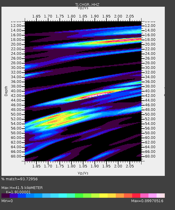
| Estimated Moho Depth: |
41.5 km |
| Estimated Crust Vp/Vs: |
1.91 |
| Assumed Crust Vp: |
6.483 km/s |
| Estimated Crust Vs: |
3.394 km/s |
| Estimated Crust Poisson's Ratio: |
0.31 |
|
| Radial Match: |
93.72956 % |
| Radial Bump: |
359 |
| Transverse Match: |
78.31043 % |
| Transverse Bump: |
400 |
| SOD ConfigId: |
13570011 |
| Insert Time: |
2019-05-01 06:42:13.795 +0000 |
| GWidth: |
2.5 |
| Max Bumps: |
400 |
| Tol: |
0.001 |
|

Signal To Noise
| Channel | StoN | STA | LTA |
| TJ:CHGR: :HHZ:20180918T07:39:09.299976Z | 14.374864 | 1.6273989E-6 | 1.13211435E-7 |
| TJ:CHGR: :HHN:20180918T07:39:09.299976Z | 7.3732843 | 7.529964E-7 | 1.02124964E-7 |
| TJ:CHGR: :HHE:20180918T07:39:09.299976Z | 2.1959965 | 1.5166398E-7 | 6.906385E-8 |
| Arrivals |
| Ps | 6.0 SECOND |
| PpPs | 18 SECOND |
| PsPs/PpSs | 24 SECOND |


