You are here: Home > Network List > TA - USArray Transportable Network (new EarthScope stations) Stations List
> Station T27A Campo, CO, USA > Earthquake Result Viewer
T27A Campo, CO, USA - Earthquake Result Viewer

| Earthquake location: |
Near S. Coast Of Honshu, Japan |
| Earthquake latitude/longitude: |
33.2/137.9 |
| Earthquake time(UTC): |
2009/08/09 (221) 10:55:55 GMT |
| Earthquake Depth: |
297 km |
| Earthquake Magnitude: |
6.5 MB, 7.1 MW, 7.1 MW |
| Earthquake Catalog/Contributor: |
WHDF/NEIC |
|
| Network: |
TA USArray Transportable Network (new EarthScope stations) |
| Station: |
T27A Campo, CO, USA |
| Lat/Lon: |
37.06 N/102.72 W |
| Elevation: |
1366 m |
|
| Distance: |
90.1 deg |
| Az: |
44.214 deg |
| Baz: |
313.014 deg |
| Ray Param: |
0.04162729 |
| Estimated Moho Depth: |
42.0 km |
| Estimated Crust Vp/Vs: |
1.82 |
| Assumed Crust Vp: |
6.306 km/s |
| Estimated Crust Vs: |
3.474 km/s |
| Estimated Crust Poisson's Ratio: |
0.28 |
|
| Radial Match: |
93.11073 % |
| Radial Bump: |
400 |
| Transverse Match: |
74.59744 % |
| Transverse Bump: |
400 |
| SOD ConfigId: |
2622 |
| Insert Time: |
2010-03-06 15:58:10.581 +0000 |
| GWidth: |
2.5 |
| Max Bumps: |
400 |
| Tol: |
0.001 |
|
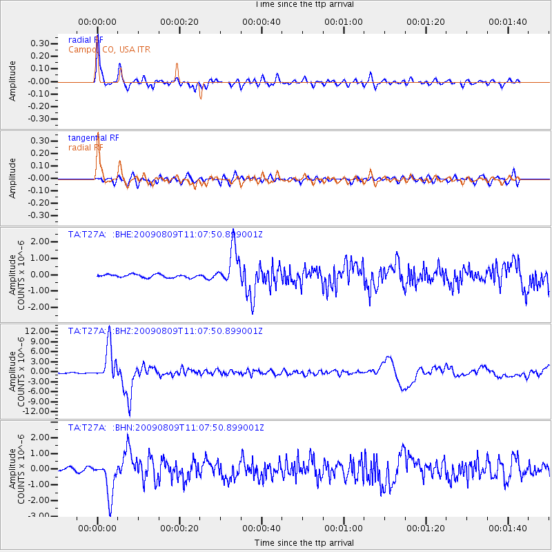
Signal To Noise
| Channel | StoN | STA | LTA |
| TA:T27A: :BHZ:20090809T11:07:50.899001Z | 52.291553 | 5.3703125E-6 | 1.02699424E-7 |
| TA:T27A: :BHN:20090809T11:07:50.899001Z | 18.147093 | 1.1823016E-6 | 6.515103E-8 |
| TA:T27A: :BHE:20090809T11:07:50.899001Z | 12.20468 | 1.1724076E-6 | 9.606213E-8 |
| Arrivals |
| Ps | 5.5 SECOND |
| PpPs | 18 SECOND |
| PsPs/PpSs | 24 SECOND |


