You are here: Home > Network List > AK - Alaska Regional Network Stations List
> Station DHY Denali Highway > Earthquake Result Viewer
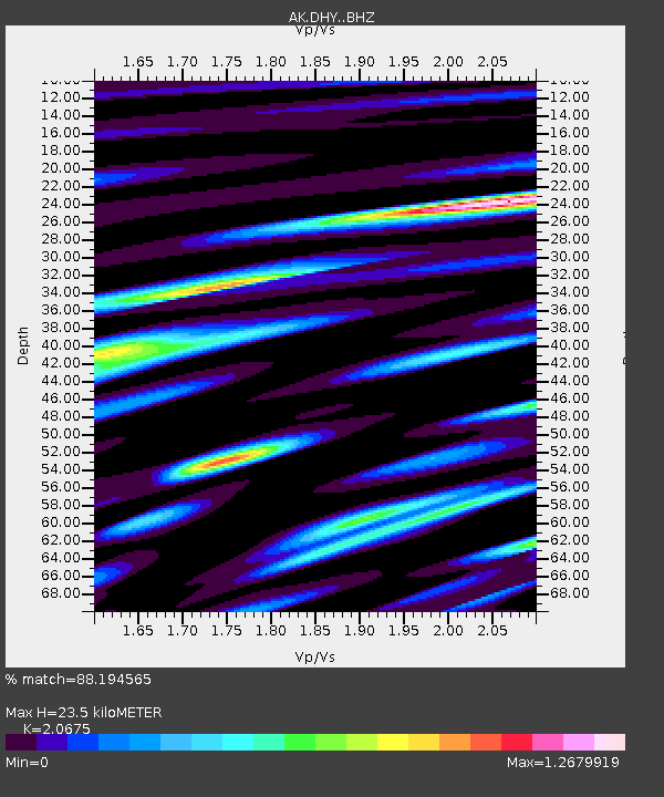
DHY Denali Highway - Earthquake Result Viewer
| Earthquake location: |
Solomon Islands |
| Earthquake latitude/longitude: |
-8.3/157.2 |
| Earthquake time(UTC): |
2018/09/18 (261) 11:57:52 GMT |
| Earthquake Depth: |
10 km |
| Earthquake Magnitude: |
5.8 Mww |
| Earthquake Catalog/Contributor: |
NEIC PDE/us |
|
| Network: |
AK Alaska Regional Network |
| Station: |
DHY Denali Highway |
| Lat/Lon: |
63.08 N/147.38 W |
| Elevation: |
1609 m |
|
| Distance: |
82.7 deg |
| Az: |
22.2 deg |
| Baz: |
235.221 deg |
| Ray Param: |
0.046728622 |
| Estimated Moho Depth: |
23.5 km |
| Estimated Crust Vp/Vs: |
2.07 |
| Assumed Crust Vp: |
6.566 km/s |
| Estimated Crust Vs: |
3.176 km/s |
| Estimated Crust Poisson's Ratio: |
0.35 |
|
| Radial Match: |
88.194565 % |
| Radial Bump: |
366 |
| Transverse Match: |
83.64319 % |
| Transverse Bump: |
400 |
| SOD ConfigId: |
13570011 |
| Insert Time: |
2019-05-01 06:43:22.656 +0000 |
| GWidth: |
2.5 |
| Max Bumps: |
400 |
| Tol: |
0.001 |
|

Signal To Noise
| Channel | StoN | STA | LTA |
| AK:DHY: :BHZ:20180918T12:09:44.147971Z | 6.493652 | 5.459518E-7 | 8.407469E-8 |
| AK:DHY: :BHN:20180918T12:09:44.147971Z | 3.365653 | 2.4247922E-7 | 7.2045225E-8 |
| AK:DHY: :BHE:20180918T12:09:44.147971Z | 2.8227227 | 1.750275E-7 | 6.200662E-8 |
| Arrivals |
| Ps | 3.9 SECOND |
| PpPs | 11 SECOND |
| PsPs/PpSs | 15 SECOND |


