You are here: Home > Network List > TA - USArray Transportable Network (new EarthScope stations) Stations List
> Station T27A Campo, CO, USA > Earthquake Result Viewer
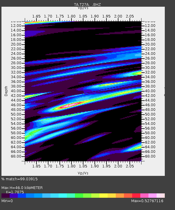
T27A Campo, CO, USA - Earthquake Result Viewer
| Earthquake location: |
Samoa Islands Region |
| Earthquake latitude/longitude: |
-15.5/-172.1 |
| Earthquake time(UTC): |
2009/09/29 (272) 17:48:10 GMT |
| Earthquake Depth: |
18 km |
| Earthquake Magnitude: |
7.1 MB, 8.1 MS, 8.1 MW, 8.0 MW |
| Earthquake Catalog/Contributor: |
WHDF/NEIC |
|
| Network: |
TA USArray Transportable Network (new EarthScope stations) |
| Station: |
T27A Campo, CO, USA |
| Lat/Lon: |
37.06 N/102.72 W |
| Elevation: |
1366 m |
|
| Distance: |
83.5 deg |
| Az: |
48.888 deg |
| Baz: |
245.243 deg |
| Ray Param: |
0.04609809 |
| Estimated Moho Depth: |
46.0 km |
| Estimated Crust Vp/Vs: |
1.79 |
| Assumed Crust Vp: |
6.306 km/s |
| Estimated Crust Vs: |
3.528 km/s |
| Estimated Crust Poisson's Ratio: |
0.27 |
|
| Radial Match: |
99.03915 % |
| Radial Bump: |
306 |
| Transverse Match: |
92.66681 % |
| Transverse Bump: |
400 |
| SOD ConfigId: |
2622 |
| Insert Time: |
2010-03-06 15:58:18.304 +0000 |
| GWidth: |
2.5 |
| Max Bumps: |
400 |
| Tol: |
0.001 |
|

Signal To Noise
| Channel | StoN | STA | LTA |
| TA:T27A: :BHZ:20090929T18:00:06.37501Z | 14.946118 | 3.326056E-6 | 2.2253644E-7 |
| TA:T27A: :BHN:20090929T18:00:06.37501Z | 3.782512 | 6.3820994E-7 | 1.6872649E-7 |
| TA:T27A: :BHE:20090929T18:00:06.37501Z | 6.967441 | 1.0516819E-6 | 1.5094234E-7 |
| Arrivals |
| Ps | 5.9 SECOND |
| PpPs | 20 SECOND |
| PsPs/PpSs | 26 SECOND |


