You are here: Home > Network List > US - United States National Seismic Network Stations List
> Station WMOK Wichita Mountains, Oklahoma, USA > Earthquake Result Viewer
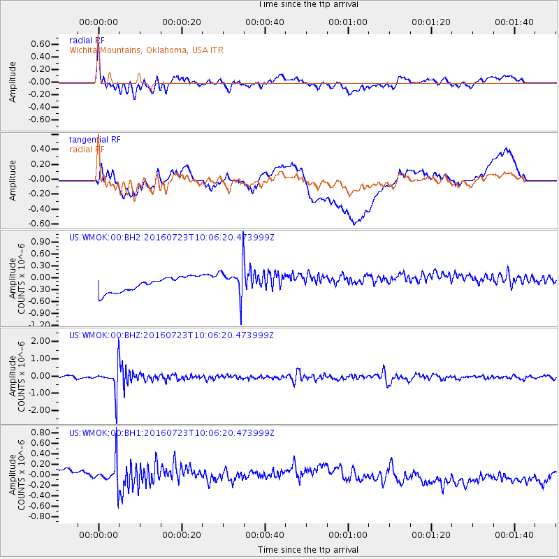
WMOK Wichita Mountains, Oklahoma, USA - Earthquake Result Viewer
*The percent match for this event was below the threshold and hence no stack was calculated.
| Earthquake location: |
Alaska Peninsula |
| Earthquake latitude/longitude: |
58.6/-156.6 |
| Earthquake time(UTC): |
2016/07/23 (205) 09:59:00 GMT |
| Earthquake Depth: |
204 km |
| Earthquake Magnitude: |
5.7 MB, 5.1 MI, 5.4 ML |
| Earthquake Catalog/Contributor: |
NEIC PDE/NEIC COMCAT |
|
| Network: |
US United States National Seismic Network |
| Station: |
WMOK Wichita Mountains, Oklahoma, USA |
| Lat/Lon: |
34.74 N/98.78 W |
| Elevation: |
486 m |
|
| Distance: |
44.5 deg |
| Az: |
96.276 deg |
| Baz: |
320.752 deg |
| Ray Param: |
$rayparam |
*The percent match for this event was below the threshold and hence was not used in the summary stack. |
|
| Radial Match: |
63.73481 % |
| Radial Bump: |
400 |
| Transverse Match: |
32.332565 % |
| Transverse Bump: |
400 |
| SOD ConfigId: |
1634031 |
| Insert Time: |
2016-08-06 10:23:43.469 +0000 |
| GWidth: |
2.5 |
| Max Bumps: |
400 |
| Tol: |
0.001 |
|
Signal To Noise
| Channel | StoN | STA | LTA |
| US:WMOK:00:BHZ:20160723T10:06:20.473999Z | 11.375068 | 7.7086395E-7 | 6.776786E-8 |
| US:WMOK:00:BH1:20160723T10:06:20.473999Z | 1.2951097 | 3.0999422E-7 | 2.393575E-7 |
| US:WMOK:00:BH2:20160723T10:06:20.473999Z | 2.1694462 | 3.9734755E-7 | 1.8315622E-7 |
| Arrivals |
| Ps | |
| PpPs | |
| PsPs/PpSs | |


