You are here: Home > Network List > TA - USArray Transportable Network (new EarthScope stations) Stations List
> Station T27A Campo, CO, USA > Earthquake Result Viewer
T27A Campo, CO, USA - Earthquake Result Viewer
| Earthquake location: |
North Of Svalbard |
| Earthquake latitude/longitude: |
80.3/-1.9 |
| Earthquake time(UTC): |
2009/03/06 (065) 10:50:29 GMT |
| Earthquake Depth: |
9.0 km |
| Earthquake Magnitude: |
6.6 MB, 6.5 MS, 6.5 MW, 6.4 MW |
| Earthquake Catalog/Contributor: |
WHDF/NEIC |
|
| Network: |
TA USArray Transportable Network (new EarthScope stations) |
| Station: |
T27A Campo, CO, USA |
| Lat/Lon: |
37.06 N/102.72 W |
| Elevation: |
1366 m |
|
| Distance: |
55.5 deg |
| Az: |
287.665 deg |
| Baz: |
11.626 deg |
| Ray Param: |
0.06473344 |
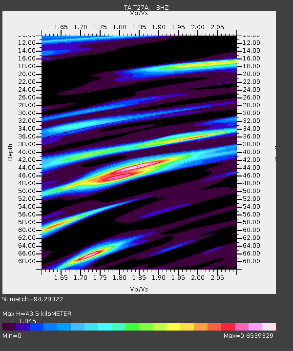
| Estimated Moho Depth: |
43.5 km |
| Estimated Crust Vp/Vs: |
1.85 |
| Assumed Crust Vp: |
6.306 km/s |
| Estimated Crust Vs: |
3.418 km/s |
| Estimated Crust Poisson's Ratio: |
0.29 |
|
| Radial Match: |
94.28822 % |
| Radial Bump: |
388 |
| Transverse Match: |
80.79702 % |
| Transverse Bump: |
400 |
| SOD ConfigId: |
2658 |
| Insert Time: |
2010-03-06 15:58:30.821 +0000 |
| GWidth: |
2.5 |
| Max Bumps: |
400 |
| Tol: |
0.001 |
|

Signal To Noise
| Channel | StoN | STA | LTA |
| TA:T27A: :BHZ:20090306T10:59:33.800015Z | 20.14098 | 4.5577294E-6 | 2.2629135E-7 |
| TA:T27A: :BHN:20090306T10:59:33.800015Z | 9.902276 | 1.8209122E-6 | 1.8388825E-7 |
| TA:T27A: :BHE:20090306T10:59:33.800015Z | 3.4744132 | 5.337392E-7 | 1.5361995E-7 |
| Arrivals |
| Ps | 6.1 SECOND |
| PpPs | 19 SECOND |
| PsPs/PpSs | 25 SECOND |


