You are here: Home > Network List > TA - USArray Transportable Network (new EarthScope stations) Stations List
> Station T27A Campo, CO, USA > Earthquake Result Viewer
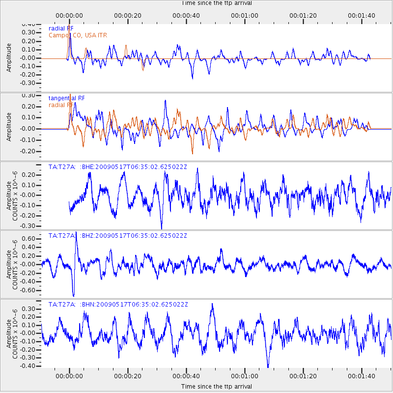
T27A Campo, CO, USA - Earthquake Result Viewer
*The percent match for this event was below the threshold and hence no stack was calculated.
| Earthquake location: |
Tonga Islands |
| Earthquake latitude/longitude: |
-16.8/-173.5 |
| Earthquake time(UTC): |
2009/05/17 (137) 06:23:03 GMT |
| Earthquake Depth: |
67 km |
| Earthquake Magnitude: |
5.5 MB, 5.6 MW, 5.6 MW |
| Earthquake Catalog/Contributor: |
WHDF/NEIC |
|
| Network: |
TA USArray Transportable Network (new EarthScope stations) |
| Station: |
T27A Campo, CO, USA |
| Lat/Lon: |
37.06 N/102.72 W |
| Elevation: |
1366 m |
|
| Distance: |
85.4 deg |
| Az: |
49.262 deg |
| Baz: |
245.118 deg |
| Ray Param: |
$rayparam |
*The percent match for this event was below the threshold and hence was not used in the summary stack. |
|
| Radial Match: |
52.604588 % |
| Radial Bump: |
400 |
| Transverse Match: |
61.49946 % |
| Transverse Bump: |
400 |
| SOD ConfigId: |
2760 |
| Insert Time: |
2010-03-06 15:58:56.057 +0000 |
| GWidth: |
2.5 |
| Max Bumps: |
400 |
| Tol: |
0.001 |
|
Signal To Noise
| Channel | StoN | STA | LTA |
| TA:T27A: :BHZ:20090517T06:35:02.625022Z | 2.9838784 | 3.3096708E-7 | 1.1091843E-7 |
| TA:T27A: :BHN:20090517T06:35:02.625022Z | 0.792569 | 8.0601396E-8 | 1.0169638E-7 |
| TA:T27A: :BHE:20090517T06:35:02.625022Z | 1.3894151 | 1.4697818E-7 | 1.057842E-7 |
| Arrivals |
| Ps | |
| PpPs | |
| PsPs/PpSs | |


