You are here: Home > Network List > AV - Alaska Volcano Observatory Stations List
> Station SPCR Ckakachatna River, Mount Spurr, Alaska > Earthquake Result Viewer
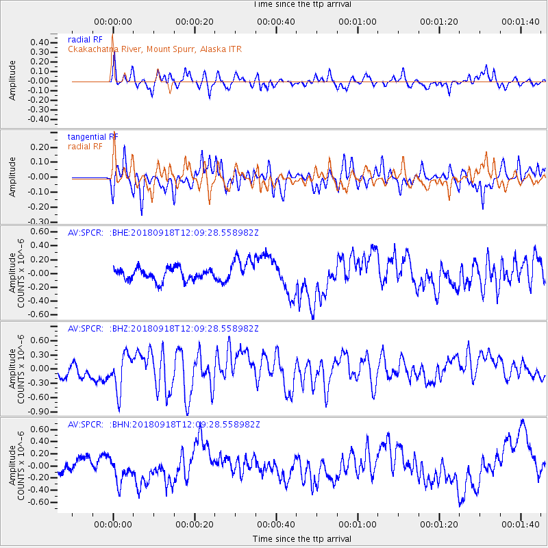
SPCR Ckakachatna River, Mount Spurr, Alaska - Earthquake Result Viewer
*The percent match for this event was below the threshold and hence no stack was calculated.
| Earthquake location: |
Solomon Islands |
| Earthquake latitude/longitude: |
-8.3/157.2 |
| Earthquake time(UTC): |
2018/09/18 (261) 11:57:52 GMT |
| Earthquake Depth: |
10 km |
| Earthquake Magnitude: |
5.8 Mww |
| Earthquake Catalog/Contributor: |
NEIC PDE/us |
|
| Network: |
AV Alaska Volcano Observatory |
| Station: |
SPCR Ckakachatna River, Mount Spurr, Alaska |
| Lat/Lon: |
61.20 N/152.21 W |
| Elevation: |
984 m |
|
| Distance: |
79.7 deg |
| Az: |
22.343 deg |
| Baz: |
230.975 deg |
| Ray Param: |
$rayparam |
*The percent match for this event was below the threshold and hence was not used in the summary stack. |
|
| Radial Match: |
55.035767 % |
| Radial Bump: |
377 |
| Transverse Match: |
55.695282 % |
| Transverse Bump: |
400 |
| SOD ConfigId: |
13570011 |
| Insert Time: |
2019-05-01 06:45:05.268 +0000 |
| GWidth: |
2.5 |
| Max Bumps: |
400 |
| Tol: |
0.001 |
|
Signal To Noise
| Channel | StoN | STA | LTA |
| AV:SPCR: :BHZ:20180918T12:09:28.558982Z | 2.420496 | 3.923288E-7 | 1.6208611E-7 |
| AV:SPCR: :BHN:20180918T12:09:28.558982Z | 2.1365223 | 2.1614201E-7 | 1.0116535E-7 |
| AV:SPCR: :BHE:20180918T12:09:28.558982Z | 2.3334715 | 2.0242614E-7 | 8.674892E-8 |
| Arrivals |
| Ps | |
| PpPs | |
| PsPs/PpSs | |


