You are here: Home > Network List > TA - USArray Transportable Network (new EarthScope stations) Stations List
> Station T27A Campo, CO, USA > Earthquake Result Viewer
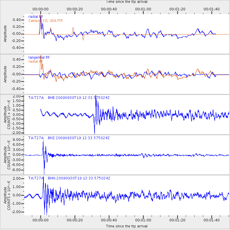
T27A Campo, CO, USA - Earthquake Result Viewer
*The percent match for this event was below the threshold and hence no stack was calculated.
| Earthquake location: |
Peru-Bolivia Border Region |
| Earthquake latitude/longitude: |
-15.6/-69.3 |
| Earthquake time(UTC): |
2009/09/30 (273) 19:03:17 GMT |
| Earthquake Depth: |
255 km |
| Earthquake Magnitude: |
5.9 MB, 5.8 MW |
| Earthquake Catalog/Contributor: |
WHDF/NEIC |
|
| Network: |
TA USArray Transportable Network (new EarthScope stations) |
| Station: |
T27A Campo, CO, USA |
| Lat/Lon: |
37.06 N/102.72 W |
| Elevation: |
1366 m |
|
| Distance: |
61.1 deg |
| Az: |
329.771 deg |
| Baz: |
142.654 deg |
| Ray Param: |
$rayparam |
*The percent match for this event was below the threshold and hence was not used in the summary stack. |
|
| Radial Match: |
67.85532 % |
| Radial Bump: |
400 |
| Transverse Match: |
63.596233 % |
| Transverse Bump: |
400 |
| SOD ConfigId: |
2622 |
| Insert Time: |
2010-03-06 15:59:21.974 +0000 |
| GWidth: |
2.5 |
| Max Bumps: |
400 |
| Tol: |
0.001 |
|
Signal To Noise
| Channel | StoN | STA | LTA |
| TA:T27A: :BHZ:20090930T19:12:33.575024Z | 29.133528 | 3.1341E-6 | 1.0757709E-7 |
| TA:T27A: :BHN:20090930T19:12:33.575024Z | 6.017762 | 9.239533E-7 | 1.5353768E-7 |
| TA:T27A: :BHE:20090930T19:12:33.575024Z | 5.4259048 | 8.4745415E-7 | 1.561867E-7 |
| Arrivals |
| Ps | |
| PpPs | |
| PsPs/PpSs | |


