You are here: Home > Network List > CI - Caltech Regional Seismic Network Stations List
> Station MPM Manuel Prospect Mine, California, USA > Earthquake Result Viewer
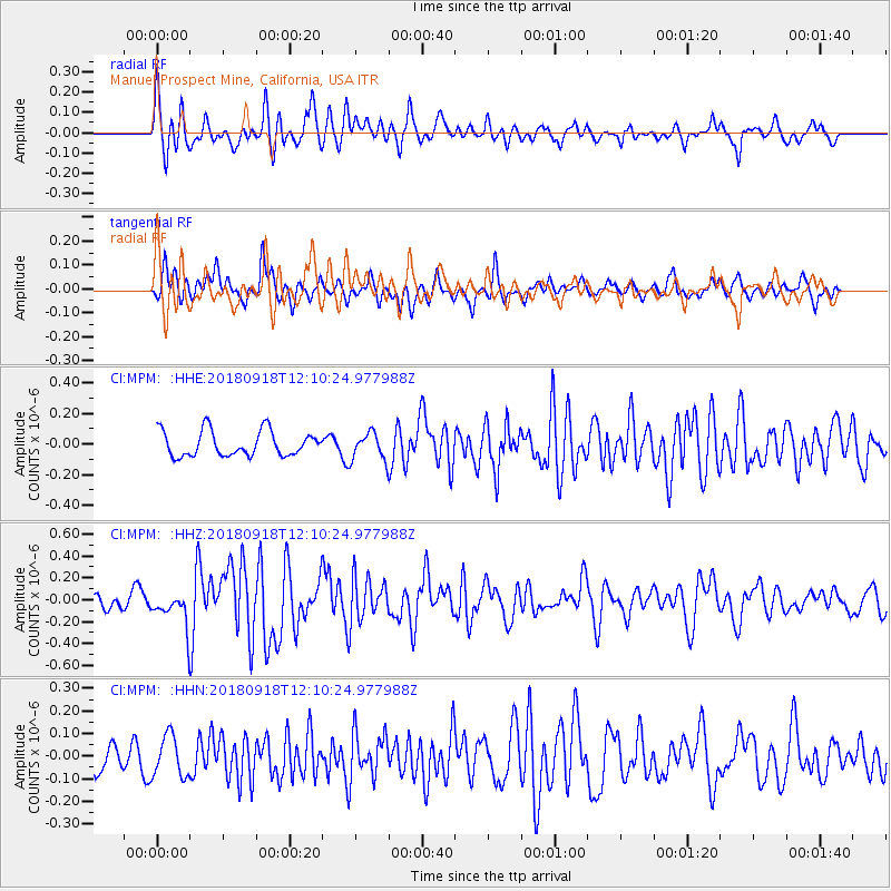
MPM Manuel Prospect Mine, California, USA - Earthquake Result Viewer
*The percent match for this event was below the threshold and hence no stack was calculated.
| Earthquake location: |
Solomon Islands |
| Earthquake latitude/longitude: |
-8.3/157.2 |
| Earthquake time(UTC): |
2018/09/18 (261) 11:57:52 GMT |
| Earthquake Depth: |
10 km |
| Earthquake Magnitude: |
5.8 Mww |
| Earthquake Catalog/Contributor: |
NEIC PDE/us |
|
| Network: |
CI Caltech Regional Seismic Network |
| Station: |
MPM Manuel Prospect Mine, California, USA |
| Lat/Lon: |
36.06 N/117.49 W |
| Elevation: |
185 m |
|
| Distance: |
91.1 deg |
| Az: |
53.872 deg |
| Baz: |
260.549 deg |
| Ray Param: |
$rayparam |
*The percent match for this event was below the threshold and hence was not used in the summary stack. |
|
| Radial Match: |
72.362076 % |
| Radial Bump: |
400 |
| Transverse Match: |
65.046486 % |
| Transverse Bump: |
400 |
| SOD ConfigId: |
13570011 |
| Insert Time: |
2019-05-01 06:46:09.325 +0000 |
| GWidth: |
2.5 |
| Max Bumps: |
400 |
| Tol: |
0.001 |
|
Signal To Noise
| Channel | StoN | STA | LTA |
| CI:MPM: :HHZ:20180918T12:10:24.977988Z | 1.9873959 | 1.5276895E-7 | 7.68689E-8 |
| CI:MPM: :HHN:20180918T12:10:24.977988Z | 2.0431745 | 9.017274E-8 | 4.4133646E-8 |
| CI:MPM: :HHE:20180918T12:10:24.977988Z | 1.0841272 | 8.9228784E-8 | 8.2304716E-8 |
| Arrivals |
| Ps | |
| PpPs | |
| PsPs/PpSs | |


