You are here: Home > Network List > TA - USArray Transportable Network (new EarthScope stations) Stations List
> Station T27A Campo, CO, USA > Earthquake Result Viewer
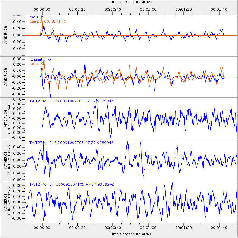
T27A Campo, CO, USA - Earthquake Result Viewer
*The percent match for this event was below the threshold and hence no stack was calculated.
| Earthquake location: |
Rat Islands, Aleutian Islands |
| Earthquake latitude/longitude: |
52.2/178.1 |
| Earthquake time(UTC): |
2009/10/07 (280) 05:38:37 GMT |
| Earthquake Depth: |
138 km |
| Earthquake Magnitude: |
5.6 MB, 5.6 MW, 5.6 MW |
| Earthquake Catalog/Contributor: |
WHDF/NEIC |
|
| Network: |
TA USArray Transportable Network (new EarthScope stations) |
| Station: |
T27A Campo, CO, USA |
| Lat/Lon: |
37.06 N/102.72 W |
| Elevation: |
1366 m |
|
| Distance: |
55.6 deg |
| Az: |
72.226 deg |
| Baz: |
312.829 deg |
| Ray Param: |
$rayparam |
*The percent match for this event was below the threshold and hence was not used in the summary stack. |
|
| Radial Match: |
53.604088 % |
| Radial Bump: |
384 |
| Transverse Match: |
65.02657 % |
| Transverse Bump: |
400 |
| SOD ConfigId: |
2622 |
| Insert Time: |
2010-03-06 15:59:25.605 +0000 |
| GWidth: |
2.5 |
| Max Bumps: |
400 |
| Tol: |
0.001 |
|
Signal To Noise
| Channel | StoN | STA | LTA |
| TA:T27A: :BHZ:20091007T05:47:27.998994Z | 3.0724223 | 2.8497564E-7 | 9.2752764E-8 |
| TA:T27A: :BHN:20091007T05:47:27.998994Z | 1.0984317 | 1.596886E-7 | 1.4537872E-7 |
| TA:T27A: :BHE:20091007T05:47:27.998994Z | 2.0860577 | 2.0939234E-7 | 1.00377065E-7 |
| Arrivals |
| Ps | |
| PpPs | |
| PsPs/PpSs | |


