You are here: Home > Network List > TA - USArray Transportable Network (new EarthScope stations) Stations List
> Station T27A Campo, CO, USA > Earthquake Result Viewer
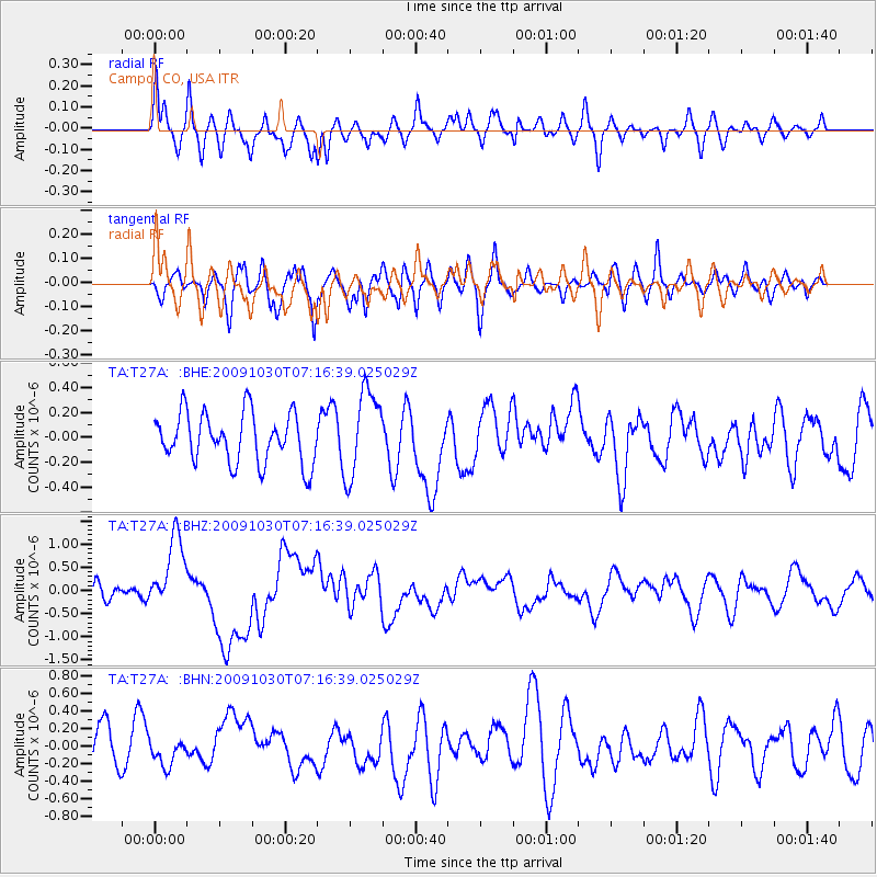
T27A Campo, CO, USA - Earthquake Result Viewer
*The percent match for this event was below the threshold and hence no stack was calculated.
| Earthquake location: |
Ryukyu Islands, Japan |
| Earthquake latitude/longitude: |
29.2/129.8 |
| Earthquake time(UTC): |
2009/10/30 (303) 07:03:39 GMT |
| Earthquake Depth: |
34 km |
| Earthquake Magnitude: |
6.3 MB, 6.8 MS, 6.8 MW, 6.8 MW |
| Earthquake Catalog/Contributor: |
WHDF/NEIC |
|
| Network: |
TA USArray Transportable Network (new EarthScope stations) |
| Station: |
T27A Campo, CO, USA |
| Lat/Lon: |
37.06 N/102.72 W |
| Elevation: |
1366 m |
|
| Distance: |
97.7 deg |
| Az: |
39.826 deg |
| Baz: |
315.582 deg |
| Ray Param: |
$rayparam |
*The percent match for this event was below the threshold and hence was not used in the summary stack. |
|
| Radial Match: |
62.537148 % |
| Radial Bump: |
400 |
| Transverse Match: |
67.3054 % |
| Transverse Bump: |
400 |
| SOD ConfigId: |
2622 |
| Insert Time: |
2010-03-06 15:59:30.432 +0000 |
| GWidth: |
2.5 |
| Max Bumps: |
400 |
| Tol: |
0.001 |
|
Signal To Noise
| Channel | StoN | STA | LTA |
| TA:T27A: :BHZ:20091030T07:16:39.025029Z | 3.559889 | 7.9959455E-7 | 2.2461221E-7 |
| TA:T27A: :BHN:20091030T07:16:39.025029Z | 0.55223477 | 1.3400243E-7 | 2.4265483E-7 |
| TA:T27A: :BHE:20091030T07:16:39.025029Z | 1.743956 | 3.466781E-7 | 1.9878833E-7 |
| Arrivals |
| Ps | |
| PpPs | |
| PsPs/PpSs | |


