You are here: Home > Network List > TA - USArray Transportable Network (new EarthScope stations) Stations List
> Station T27A Campo, CO, USA > Earthquake Result Viewer
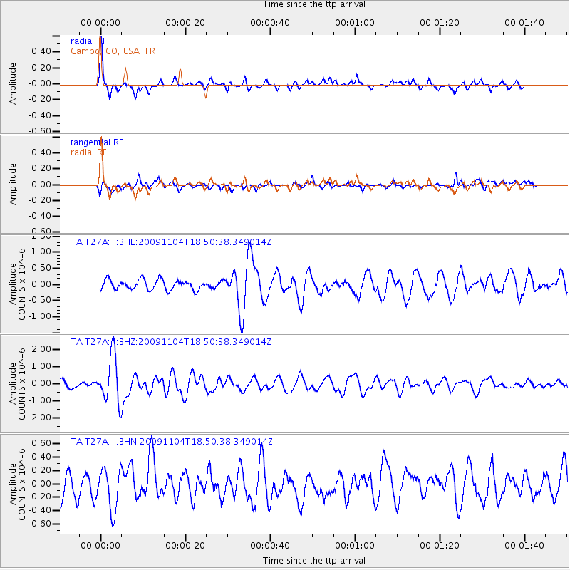
T27A Campo, CO, USA - Earthquake Result Viewer
*The percent match for this event was below the threshold and hence no stack was calculated.
| Earthquake location: |
Azores Islands Region |
| Earthquake latitude/longitude: |
36.2/-33.9 |
| Earthquake time(UTC): |
2009/11/04 (308) 18:41:44 GMT |
| Earthquake Depth: |
10 km |
| Earthquake Magnitude: |
5.7 MB, 5.6 MS, 5.9 MW, 5.8 MW |
| Earthquake Catalog/Contributor: |
WHDF/NEIC |
|
| Network: |
TA USArray Transportable Network (new EarthScope stations) |
| Station: |
T27A Campo, CO, USA |
| Lat/Lon: |
37.06 N/102.72 W |
| Elevation: |
1366 m |
|
| Distance: |
54.1 deg |
| Az: |
292.964 deg |
| Baz: |
68.679 deg |
| Ray Param: |
$rayparam |
*The percent match for this event was below the threshold and hence was not used in the summary stack. |
|
| Radial Match: |
75.24867 % |
| Radial Bump: |
325 |
| Transverse Match: |
52.16568 % |
| Transverse Bump: |
400 |
| SOD ConfigId: |
2622 |
| Insert Time: |
2010-03-06 15:59:32.938 +0000 |
| GWidth: |
2.5 |
| Max Bumps: |
400 |
| Tol: |
0.001 |
|
Signal To Noise
| Channel | StoN | STA | LTA |
| TA:T27A: :BHZ:20091104T18:50:38.349014Z | 5.886684 | 1.3910976E-6 | 2.363126E-7 |
| TA:T27A: :BHN:20091104T18:50:38.349014Z | 1.6275734 | 3.23891E-7 | 1.9900239E-7 |
| TA:T27A: :BHE:20091104T18:50:38.349014Z | 4.5007787 | 6.8327626E-7 | 1.518129E-7 |
| Arrivals |
| Ps | |
| PpPs | |
| PsPs/PpSs | |


