You are here: Home > Network List > TA - USArray Transportable Network (new EarthScope stations) Stations List
> Station B18K Kokolik River, AK, USA > Earthquake Result Viewer
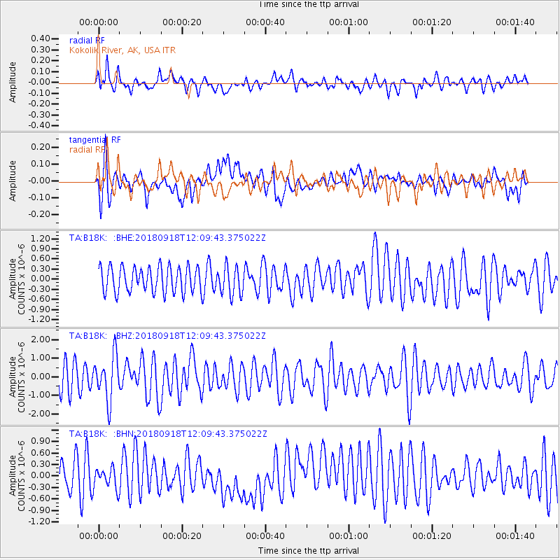
B18K Kokolik River, AK, USA - Earthquake Result Viewer
*The percent match for this event was below the threshold and hence no stack was calculated.
| Earthquake location: |
Solomon Islands |
| Earthquake latitude/longitude: |
-8.3/157.2 |
| Earthquake time(UTC): |
2018/09/18 (261) 11:57:52 GMT |
| Earthquake Depth: |
10 km |
| Earthquake Magnitude: |
5.8 Mww |
| Earthquake Catalog/Contributor: |
NEIC PDE/us |
|
| Network: |
TA USArray Transportable Network (new EarthScope stations) |
| Station: |
B18K Kokolik River, AK, USA |
| Lat/Lon: |
69.36 N/161.80 W |
| Elevation: |
222 m |
|
| Distance: |
82.5 deg |
| Az: |
13.561 deg |
| Baz: |
220.887 deg |
| Ray Param: |
$rayparam |
*The percent match for this event was below the threshold and hence was not used in the summary stack. |
|
| Radial Match: |
65.84831 % |
| Radial Bump: |
400 |
| Transverse Match: |
51.349014 % |
| Transverse Bump: |
400 |
| SOD ConfigId: |
13570011 |
| Insert Time: |
2019-05-01 06:48:55.349 +0000 |
| GWidth: |
2.5 |
| Max Bumps: |
400 |
| Tol: |
0.001 |
|
Signal To Noise
| Channel | StoN | STA | LTA |
| TA:B18K: :BHZ:20180918T12:09:43.375022Z | 2.004019 | 1.2392294E-6 | 6.183721E-7 |
| TA:B18K: :BHN:20180918T12:09:43.375022Z | 0.64058584 | 2.6426105E-7 | 4.1253028E-7 |
| TA:B18K: :BHE:20180918T12:09:43.375022Z | 1.1614745 | 4.3116202E-7 | 3.7121953E-7 |
| Arrivals |
| Ps | |
| PpPs | |
| PsPs/PpSs | |


