You are here: Home > Network List > TA - USArray Transportable Network (new EarthScope stations) Stations List
> Station E29M Blow River, YT, CAN > Earthquake Result Viewer
E29M Blow River, YT, CAN - Earthquake Result Viewer
| Earthquake location: |
Solomon Islands |
| Earthquake latitude/longitude: |
-8.3/157.2 |
| Earthquake time(UTC): |
2018/09/18 (261) 11:57:52 GMT |
| Earthquake Depth: |
10 km |
| Earthquake Magnitude: |
5.8 Mww |
| Earthquake Catalog/Contributor: |
NEIC PDE/us |
|
| Network: |
TA USArray Transportable Network (new EarthScope stations) |
| Station: |
E29M Blow River, YT, CAN |
| Lat/Lon: |
68.39 N/137.90 W |
| Elevation: |
324 m |
|
| Distance: |
88.7 deg |
| Az: |
19.603 deg |
| Baz: |
243.67 deg |
| Ray Param: |
0.04235862 |
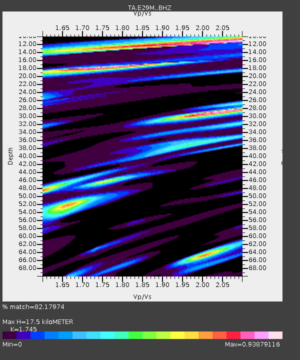
| Estimated Moho Depth: |
17.5 km |
| Estimated Crust Vp/Vs: |
1.75 |
| Assumed Crust Vp: |
5.981 km/s |
| Estimated Crust Vs: |
3.428 km/s |
| Estimated Crust Poisson's Ratio: |
0.26 |
|
| Radial Match: |
82.17974 % |
| Radial Bump: |
400 |
| Transverse Match: |
72.28422 % |
| Transverse Bump: |
400 |
| SOD ConfigId: |
13570011 |
| Insert Time: |
2019-05-01 06:49:16.658 +0000 |
| GWidth: |
2.5 |
| Max Bumps: |
400 |
| Tol: |
0.001 |
|

Signal To Noise
| Channel | StoN | STA | LTA |
| TA:E29M: :BHZ:20180918T12:10:14.224998Z | 4.6020403 | 4.4788933E-7 | 9.7324076E-8 |
| TA:E29M: :BHN:20180918T12:10:14.224998Z | 1.087738 | 8.762716E-8 | 8.055906E-8 |
| TA:E29M: :BHE:20180918T12:10:14.224998Z | 1.8112988 | 1.4498868E-7 | 8.00468E-8 |
| Arrivals |
| Ps | 2.2 SECOND |
| PpPs | 7.9 SECOND |
| PsPs/PpSs | 10 SECOND |


