You are here: Home > Network List > TA - USArray Transportable Network (new EarthScope stations) Stations List
> Station F19K Shaleruckik Mountain, AK, USA > Earthquake Result Viewer
F19K Shaleruckik Mountain, AK, USA - Earthquake Result Viewer
| Earthquake location: |
Solomon Islands |
| Earthquake latitude/longitude: |
-8.3/157.2 |
| Earthquake time(UTC): |
2018/09/18 (261) 11:57:52 GMT |
| Earthquake Depth: |
10 km |
| Earthquake Magnitude: |
5.8 Mww |
| Earthquake Catalog/Contributor: |
NEIC PDE/us |
|
| Network: |
TA USArray Transportable Network (new EarthScope stations) |
| Station: |
F19K Shaleruckik Mountain, AK, USA |
| Lat/Lon: |
66.83 N/157.77 W |
| Elevation: |
161 m |
|
| Distance: |
81.7 deg |
| Az: |
16.427 deg |
| Baz: |
225.016 deg |
| Ray Param: |
0.04741422 |
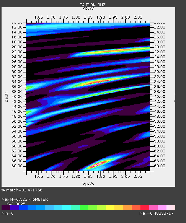
| Estimated Moho Depth: |
67.25 km |
| Estimated Crust Vp/Vs: |
1.88 |
| Assumed Crust Vp: |
6.577 km/s |
| Estimated Crust Vs: |
3.494 km/s |
| Estimated Crust Poisson's Ratio: |
0.30 |
|
| Radial Match: |
83.471756 % |
| Radial Bump: |
400 |
| Transverse Match: |
73.47207 % |
| Transverse Bump: |
400 |
| SOD ConfigId: |
13570011 |
| Insert Time: |
2019-05-01 06:49:20.866 +0000 |
| GWidth: |
2.5 |
| Max Bumps: |
400 |
| Tol: |
0.001 |
|

Signal To Noise
| Channel | StoN | STA | LTA |
| TA:F19K: :BHZ:20180918T12:09:39.024985Z | 4.866988 | 4.789959E-7 | 9.841732E-8 |
| TA:F19K: :BHN:20180918T12:09:39.024985Z | 1.8469226 | 1.4243571E-7 | 7.712056E-8 |
| TA:F19K: :BHE:20180918T12:09:39.024985Z | 2.1005557 | 1.2981567E-7 | 6.1800634E-8 |
| Arrivals |
| Ps | 9.3 SECOND |
| PpPs | 29 SECOND |
| PsPs/PpSs | 38 SECOND |


