You are here: Home > Network List > TA - USArray Transportable Network (new EarthScope stations) Stations List
> Station I20K Naaghedeneel ne tl'uh kk'aat, AK, USA > Earthquake Result Viewer
I20K Naaghedeneel ne tl'uh kk'aat, AK, USA - Earthquake Result Viewer
| Earthquake location: |
Solomon Islands |
| Earthquake latitude/longitude: |
-8.3/157.2 |
| Earthquake time(UTC): |
2018/09/18 (261) 11:57:52 GMT |
| Earthquake Depth: |
10 km |
| Earthquake Magnitude: |
5.8 Mww |
| Earthquake Catalog/Contributor: |
NEIC PDE/us |
|
| Network: |
TA USArray Transportable Network (new EarthScope stations) |
| Station: |
I20K Naaghedeneel ne tl'uh kk'aat, AK, USA |
| Lat/Lon: |
64.80 N/154.48 W |
| Elevation: |
75 m |
|
| Distance: |
81.3 deg |
| Az: |
18.873 deg |
| Baz: |
228.381 deg |
| Ray Param: |
0.047705915 |
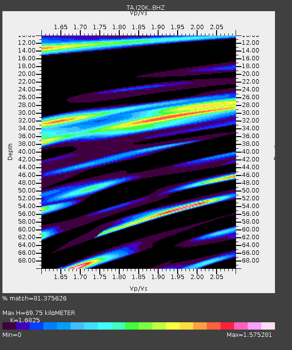
| Estimated Moho Depth: |
69.75 km |
| Estimated Crust Vp/Vs: |
1.68 |
| Assumed Crust Vp: |
6.566 km/s |
| Estimated Crust Vs: |
3.903 km/s |
| Estimated Crust Poisson's Ratio: |
0.23 |
|
| Radial Match: |
81.375626 % |
| Radial Bump: |
357 |
| Transverse Match: |
81.32025 % |
| Transverse Bump: |
400 |
| SOD ConfigId: |
13570011 |
| Insert Time: |
2019-05-01 06:49:49.959 +0000 |
| GWidth: |
2.5 |
| Max Bumps: |
400 |
| Tol: |
0.001 |
|

Signal To Noise
| Channel | StoN | STA | LTA |
| TA:I20K: :BHZ:20180918T12:09:36.824973Z | 8.88536 | 6.089979E-7 | 6.853948E-8 |
| TA:I20K: :BHN:20180918T12:09:36.824973Z | 1.2422483 | 1.9716113E-7 | 1.5871314E-7 |
| TA:I20K: :BHE:20180918T12:09:36.824973Z | 1.6110632 | 3.7048093E-7 | 2.2996052E-7 |
| Arrivals |
| Ps | 7.5 SECOND |
| PpPs | 28 SECOND |
| PsPs/PpSs | 35 SECOND |


