You are here: Home > Network List > TA - USArray Transportable Network (new EarthScope stations) Stations List
> Station M11K Mekoryuk, AK, USA > Earthquake Result Viewer
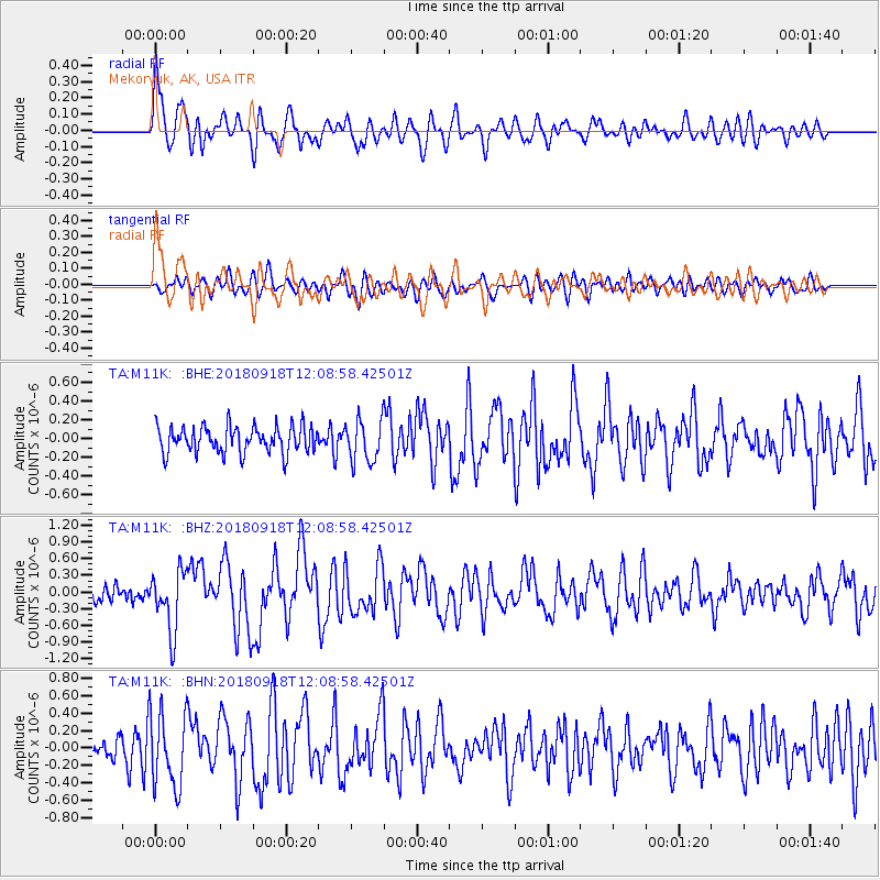
M11K Mekoryuk, AK, USA - Earthquake Result Viewer
*The percent match for this event was below the threshold and hence no stack was calculated.
| Earthquake location: |
Solomon Islands |
| Earthquake latitude/longitude: |
-8.3/157.2 |
| Earthquake time(UTC): |
2018/09/18 (261) 11:57:52 GMT |
| Earthquake Depth: |
10 km |
| Earthquake Magnitude: |
5.8 Mww |
| Earthquake Catalog/Contributor: |
NEIC PDE/us |
|
| Network: |
TA USArray Transportable Network (new EarthScope stations) |
| Station: |
M11K Mekoryuk, AK, USA |
| Lat/Lon: |
60.38 N/166.20 W |
| Elevation: |
3.0 m |
|
| Distance: |
74.3 deg |
| Az: |
17.903 deg |
| Baz: |
217.769 deg |
| Ray Param: |
$rayparam |
*The percent match for this event was below the threshold and hence was not used in the summary stack. |
|
| Radial Match: |
67.68234 % |
| Radial Bump: |
400 |
| Transverse Match: |
61.281685 % |
| Transverse Bump: |
400 |
| SOD ConfigId: |
13570011 |
| Insert Time: |
2019-05-01 06:50:16.940 +0000 |
| GWidth: |
2.5 |
| Max Bumps: |
400 |
| Tol: |
0.001 |
|
Signal To Noise
| Channel | StoN | STA | LTA |
| TA:M11K: :BHZ:20180918T12:08:58.42501Z | 3.0538428 | 5.3628895E-7 | 1.7561118E-7 |
| TA:M11K: :BHN:20180918T12:08:58.42501Z | 2.5149024 | 4.295486E-7 | 1.7080131E-7 |
| TA:M11K: :BHE:20180918T12:08:58.42501Z | 1.5790473 | 2.2315143E-7 | 1.413203E-7 |
| Arrivals |
| Ps | |
| PpPs | |
| PsPs/PpSs | |


