You are here: Home > Network List > TA - USArray Transportable Network (new EarthScope stations) Stations List
> Station M26K Nabesna, AK, USA > Earthquake Result Viewer
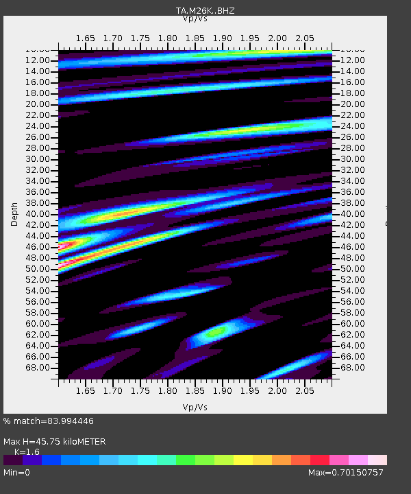
M26K Nabesna, AK, USA - Earthquake Result Viewer
| Earthquake location: |
Solomon Islands |
| Earthquake latitude/longitude: |
-8.3/157.2 |
| Earthquake time(UTC): |
2018/09/18 (261) 11:57:52 GMT |
| Earthquake Depth: |
10 km |
| Earthquake Magnitude: |
5.8 Mww |
| Earthquake Catalog/Contributor: |
NEIC PDE/us |
|
| Network: |
TA USArray Transportable Network (new EarthScope stations) |
| Station: |
M26K Nabesna, AK, USA |
| Lat/Lon: |
62.40 N/143.00 W |
| Elevation: |
888 m |
|
| Distance: |
84.0 deg |
| Az: |
23.871 deg |
| Baz: |
239.303 deg |
| Ray Param: |
0.045789856 |
| Estimated Moho Depth: |
45.75 km |
| Estimated Crust Vp/Vs: |
1.60 |
| Assumed Crust Vp: |
6.566 km/s |
| Estimated Crust Vs: |
4.104 km/s |
| Estimated Crust Poisson's Ratio: |
0.18 |
|
| Radial Match: |
83.994446 % |
| Radial Bump: |
400 |
| Transverse Match: |
81.145615 % |
| Transverse Bump: |
400 |
| SOD ConfigId: |
13570011 |
| Insert Time: |
2019-05-01 06:50:26.275 +0000 |
| GWidth: |
2.5 |
| Max Bumps: |
400 |
| Tol: |
0.001 |
|

Signal To Noise
| Channel | StoN | STA | LTA |
| TA:M26K: :BHZ:20180918T12:09:50.974998Z | 6.8810816 | 3.6248096E-7 | 5.2677905E-8 |
| TA:M26K: :BHN:20180918T12:09:50.974998Z | 1.6299196 | 9.264054E-8 | 5.683749E-8 |
| TA:M26K: :BHE:20180918T12:09:50.974998Z | 1.4105878 | 9.361211E-8 | 6.6363896E-8 |
| Arrivals |
| Ps | 4.3 SECOND |
| PpPs | 18 SECOND |
| PsPs/PpSs | 22 SECOND |


