You are here: Home > Network List > TA - USArray Transportable Network (new EarthScope stations) Stations List
> Station R33M Jennings River, BC, CAN > Earthquake Result Viewer
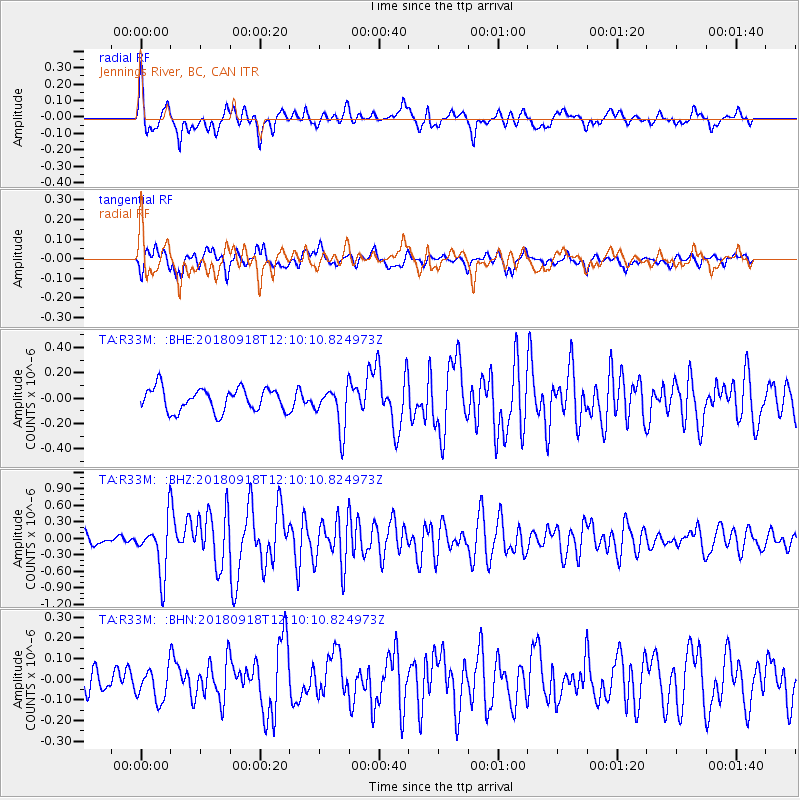
R33M Jennings River, BC, CAN - Earthquake Result Viewer
*The percent match for this event was below the threshold and hence no stack was calculated.
| Earthquake location: |
Solomon Islands |
| Earthquake latitude/longitude: |
-8.3/157.2 |
| Earthquake time(UTC): |
2018/09/18 (261) 11:57:52 GMT |
| Earthquake Depth: |
10 km |
| Earthquake Magnitude: |
5.8 Mww |
| Earthquake Catalog/Contributor: |
NEIC PDE/us |
|
| Network: |
TA USArray Transportable Network (new EarthScope stations) |
| Station: |
R33M Jennings River, BC, CAN |
| Lat/Lon: |
59.39 N/130.97 W |
| Elevation: |
1437 m |
|
| Distance: |
88.0 deg |
| Az: |
29.104 deg |
| Baz: |
250.174 deg |
| Ray Param: |
$rayparam |
*The percent match for this event was below the threshold and hence was not used in the summary stack. |
|
| Radial Match: |
75.87861 % |
| Radial Bump: |
399 |
| Transverse Match: |
76.577194 % |
| Transverse Bump: |
341 |
| SOD ConfigId: |
13570011 |
| Insert Time: |
2019-05-01 06:51:02.230 +0000 |
| GWidth: |
2.5 |
| Max Bumps: |
400 |
| Tol: |
0.001 |
|
Signal To Noise
| Channel | StoN | STA | LTA |
| TA:R33M: :BHZ:20180918T12:10:10.824973Z | 5.445343 | 4.849052E-7 | 8.9049514E-8 |
| TA:R33M: :BHN:20180918T12:10:10.824973Z | 1.1432543 | 8.0301646E-8 | 7.023954E-8 |
| TA:R33M: :BHE:20180918T12:10:10.824973Z | 1.867357 | 1.6955478E-7 | 9.079934E-8 |
| Arrivals |
| Ps | |
| PpPs | |
| PsPs/PpSs | |


