You are here: Home > Network List > TA - USArray Transportable Network (new EarthScope stations) Stations List
> Station S31K Pelican, AK, USA > Earthquake Result Viewer
S31K Pelican, AK, USA - Earthquake Result Viewer
| Earthquake location: |
Solomon Islands |
| Earthquake latitude/longitude: |
-8.3/157.2 |
| Earthquake time(UTC): |
2018/09/18 (261) 11:57:52 GMT |
| Earthquake Depth: |
10 km |
| Earthquake Magnitude: |
5.8 Mww |
| Earthquake Catalog/Contributor: |
NEIC PDE/us |
|
| Network: |
TA USArray Transportable Network (new EarthScope stations) |
| Station: |
S31K Pelican, AK, USA |
| Lat/Lon: |
57.96 N/136.23 W |
| Elevation: |
34 m |
|
| Distance: |
84.9 deg |
| Az: |
29.402 deg |
| Baz: |
245.701 deg |
| Ray Param: |
0.04512057 |
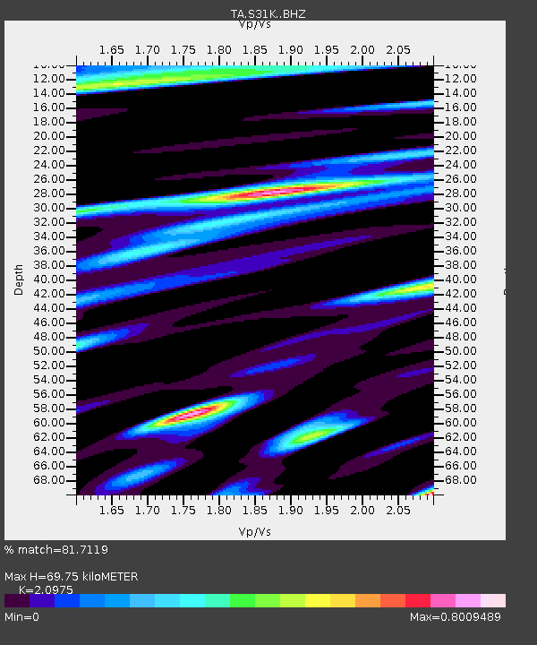
| Estimated Moho Depth: |
69.75 km |
| Estimated Crust Vp/Vs: |
2.10 |
| Assumed Crust Vp: |
6.134 km/s |
| Estimated Crust Vs: |
2.924 km/s |
| Estimated Crust Poisson's Ratio: |
0.35 |
|
| Radial Match: |
81.7119 % |
| Radial Bump: |
400 |
| Transverse Match: |
71.855354 % |
| Transverse Bump: |
400 |
| SOD ConfigId: |
13570011 |
| Insert Time: |
2019-05-01 06:51:04.934 +0000 |
| GWidth: |
2.5 |
| Max Bumps: |
400 |
| Tol: |
0.001 |
|

Signal To Noise
| Channel | StoN | STA | LTA |
| TA:S31K: :BHZ:20180918T12:09:55.750022Z | 4.48947 | 5.5997106E-7 | 1.2472988E-7 |
| TA:S31K: :BHN:20180918T12:09:55.750022Z | 1.5640234 | 1.2069167E-7 | 7.7167435E-8 |
| TA:S31K: :BHE:20180918T12:09:55.750022Z | 2.0755038 | 2.3527267E-7 | 1.133569E-7 |
| Arrivals |
| Ps | 13 SECOND |
| PpPs | 35 SECOND |
| PsPs/PpSs | 47 SECOND |


