You are here: Home > Network List > TA - USArray Transportable Network (new EarthScope stations) Stations List
> Station J13A Cove Ranch, Picabo, ID, USA > Earthquake Result Viewer
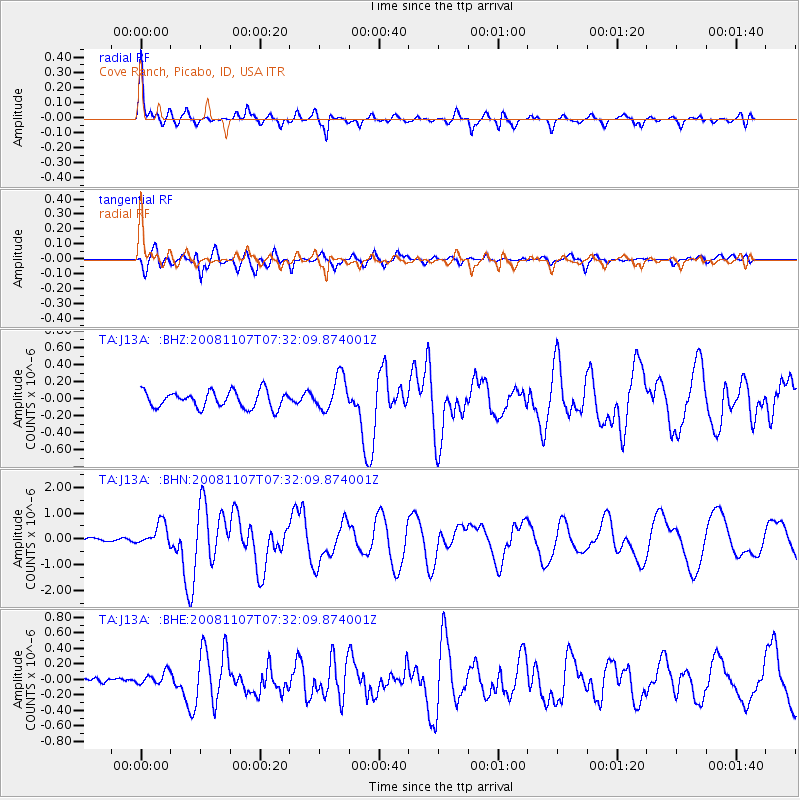
J13A Cove Ranch, Picabo, ID, USA - Earthquake Result Viewer

| Earthquake location: |
Vanuatu Islands |
| Earthquake latitude/longitude: |
-14.8/168.0 |
| Earthquake time(UTC): |
2008/11/07 (312) 07:19:35 GMT |
| Earthquake Depth: |
13 km |
| Earthquake Magnitude: |
6.0 MB, 6.3 MS, 6.4 MW, 6.4 MW |
| Earthquake Catalog/Contributor: |
WHDF/NEIC |
|
| Network: |
TA USArray Transportable Network (new EarthScope stations) |
| Station: |
J13A Cove Ranch, Picabo, ID, USA |
| Lat/Lon: |
43.40 N/114.17 W |
| Elevation: |
1552 m |
|
| Distance: |
91.4 deg |
| Az: |
45.451 deg |
| Baz: |
251.006 deg |
| Ray Param: |
0.04160164 |
| Estimated Moho Depth: |
69.75 km |
| Estimated Crust Vp/Vs: |
1.68 |
| Assumed Crust Vp: |
6.291 km/s |
| Estimated Crust Vs: |
3.739 km/s |
| Estimated Crust Poisson's Ratio: |
0.23 |
|
| Radial Match: |
92.20574 % |
| Radial Bump: |
382 |
| Transverse Match: |
85.92694 % |
| Transverse Bump: |
400 |
| SOD ConfigId: |
2658 |
| Insert Time: |
2010-03-06 16:00:49.241 +0000 |
| GWidth: |
2.5 |
| Max Bumps: |
400 |
| Tol: |
0.001 |
|
Signal To Noise
| Channel | StoN | STA | LTA |
| TA:J13A: :BHN:20081107T07:32:09.874001Z | 5.325323 | 4.4711658E-7 | 8.396046E-8 |
| TA:J13A: :BHE:20081107T07:32:09.874001Z | 0.84537 | 8.2678454E-8 | 9.78015E-8 |
| TA:J13A: :BHZ:20081107T07:32:09.874001Z | 2.0618455 | 2.0003642E-7 | 9.701814E-8 |
| Arrivals |
| Ps | 7.7 SECOND |
| PpPs | 29 SECOND |
| PsPs/PpSs | 37 SECOND |


