You are here: Home > Network List > TA - USArray Transportable Network (new EarthScope stations) Stations List
> Station J13A Cove Ranch, Picabo, ID, USA > Earthquake Result Viewer
J13A Cove Ranch, Picabo, ID, USA - Earthquake Result Viewer
| Earthquake location: |
Kermadec Islands, New Zealand |
| Earthquake latitude/longitude: |
-29.8/-177.7 |
| Earthquake time(UTC): |
2008/09/29 (273) 15:19:31 GMT |
| Earthquake Depth: |
36 km |
| Earthquake Magnitude: |
6.5 MB, 6.7 MS, 7.0 MW, 7.0 MW |
| Earthquake Catalog/Contributor: |
WHDF/NEIC |
|
| Network: |
TA USArray Transportable Network (new EarthScope stations) |
| Station: |
J13A Cove Ranch, Picabo, ID, USA |
| Lat/Lon: |
43.40 N/114.17 W |
| Elevation: |
1552 m |
|
| Distance: |
93.2 deg |
| Az: |
40.796 deg |
| Baz: |
231.212 deg |
| Ray Param: |
0.04130076 |
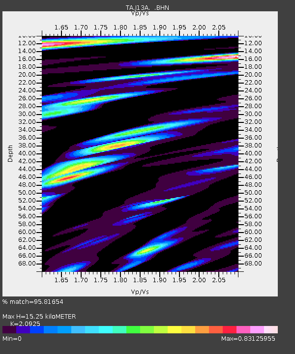
| Estimated Moho Depth: |
15.25 km |
| Estimated Crust Vp/Vs: |
2.09 |
| Assumed Crust Vp: |
6.291 km/s |
| Estimated Crust Vs: |
3.007 km/s |
| Estimated Crust Poisson's Ratio: |
0.35 |
|
| Radial Match: |
95.81654 % |
| Radial Bump: |
400 |
| Transverse Match: |
88.58053 % |
| Transverse Bump: |
400 |
| SOD ConfigId: |
2560 |
| Insert Time: |
2010-03-06 16:00:59.380 +0000 |
| GWidth: |
2.5 |
| Max Bumps: |
400 |
| Tol: |
0.001 |
|
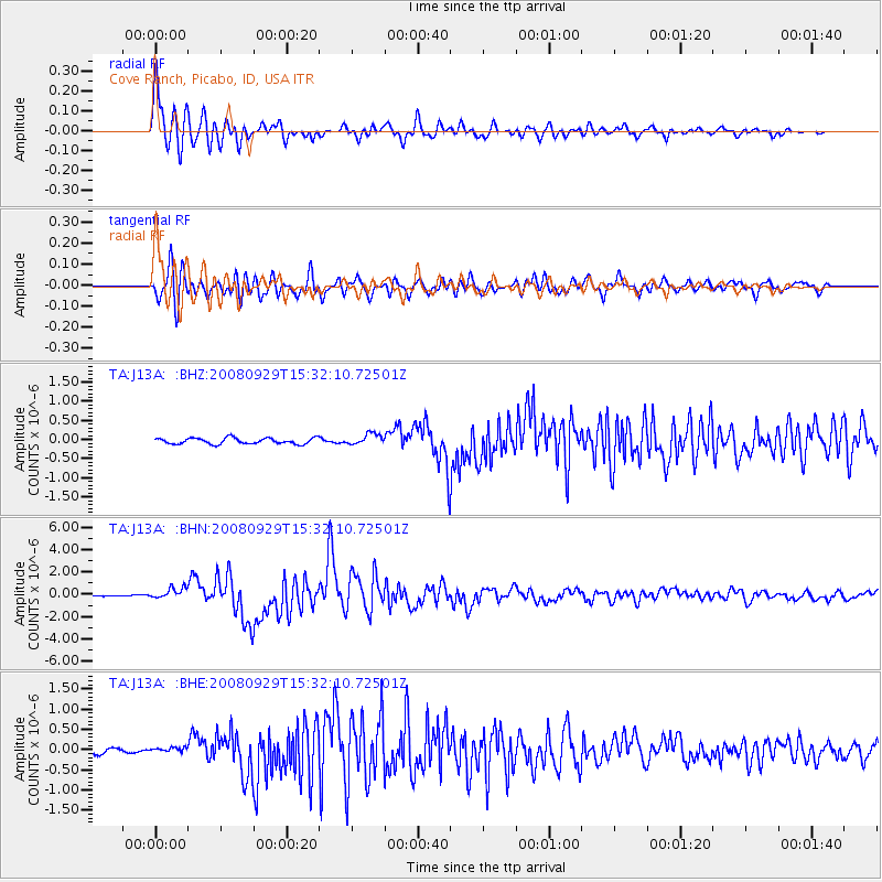
Signal To Noise
| Channel | StoN | STA | LTA |
| TA:J13A: :BHN:20080929T15:32:10.72501Z | 8.028775 | 4.785504E-7 | 5.9604414E-8 |
| TA:J13A: :BHE:20080929T15:32:10.72501Z | 1.0464208 | 6.052121E-8 | 5.7836395E-8 |
| TA:J13A: :BHZ:20080929T15:32:10.72501Z | 1.8371476 | 1.4361444E-7 | 7.817251E-8 |
| Arrivals |
| Ps | 2.7 SECOND |
| PpPs | 7.4 SECOND |
| PsPs/PpSs | 10 SECOND |


