You are here: Home > Network List > XV14 - Fault Locations and Alaska Tectonics from Seismicity Stations List
> Station FTGH Toghotthele, Parks Hwy, AK, USA > Earthquake Result Viewer
FTGH Toghotthele, Parks Hwy, AK, USA - Earthquake Result Viewer
| Earthquake location: |
Solomon Islands |
| Earthquake latitude/longitude: |
-8.3/157.2 |
| Earthquake time(UTC): |
2018/09/18 (261) 11:57:52 GMT |
| Earthquake Depth: |
10 km |
| Earthquake Magnitude: |
5.8 Mww |
| Earthquake Catalog/Contributor: |
NEIC PDE/us |
|
| Network: |
XV Fault Locations and Alaska Tectonics from Seismicity |
| Station: |
FTGH Toghotthele, Parks Hwy, AK, USA |
| Lat/Lon: |
64.69 N/148.83 W |
| Elevation: |
286 m |
|
| Distance: |
83.1 deg |
| Az: |
20.493 deg |
| Baz: |
233.707 deg |
| Ray Param: |
0.046436366 |
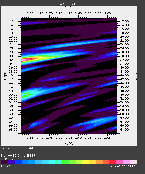
| Estimated Moho Depth: |
32.0 km |
| Estimated Crust Vp/Vs: |
1.60 |
| Assumed Crust Vp: |
6.566 km/s |
| Estimated Crust Vs: |
4.104 km/s |
| Estimated Crust Poisson's Ratio: |
0.18 |
|
| Radial Match: |
80.300644 % |
| Radial Bump: |
400 |
| Transverse Match: |
74.77571 % |
| Transverse Bump: |
400 |
| SOD ConfigId: |
13570011 |
| Insert Time: |
2019-05-01 06:52:21.201 +0000 |
| GWidth: |
2.5 |
| Max Bumps: |
400 |
| Tol: |
0.001 |
|

Signal To Noise
| Channel | StoN | STA | LTA |
| XV:FTGH: :HHZ:20180918T12:09:46.320029Z | 7.6180253 | 4.775433E-7 | 6.268598E-8 |
| XV:FTGH: :HHN:20180918T12:09:46.320029Z | 1.8293782 | 9.636209E-8 | 5.267478E-8 |
| XV:FTGH: :HHE:20180918T12:09:46.320029Z | 2.7407396 | 1.4286861E-7 | 5.212776E-8 |
| Arrivals |
| Ps | 3.0 SECOND |
| PpPs | 12 SECOND |
| PsPs/PpSs | 15 SECOND |


