You are here: Home > Network List > TA - USArray Transportable Network (new EarthScope stations) Stations List
> Station J13A Cove Ranch, Picabo, ID, USA > Earthquake Result Viewer
J13A Cove Ranch, Picabo, ID, USA - Earthquake Result Viewer
| Earthquake location: |
Solomon Islands |
| Earthquake latitude/longitude: |
-9.8/159.5 |
| Earthquake time(UTC): |
2007/08/16 (228) 08:39:27 GMT |
| Earthquake Depth: |
10 km |
| Earthquake Magnitude: |
6.1 MB, 6.7 MS, 6.4 MW |
| Earthquake Catalog/Contributor: |
WHDF/NEIC |
|
| Network: |
TA USArray Transportable Network (new EarthScope stations) |
| Station: |
J13A Cove Ranch, Picabo, ID, USA |
| Lat/Lon: |
43.40 N/114.17 W |
| Elevation: |
1552 m |
|
| Distance: |
94.0 deg |
| Az: |
46.823 deg |
| Baz: |
260.393 deg |
| Ray Param: |
0.041135684 |
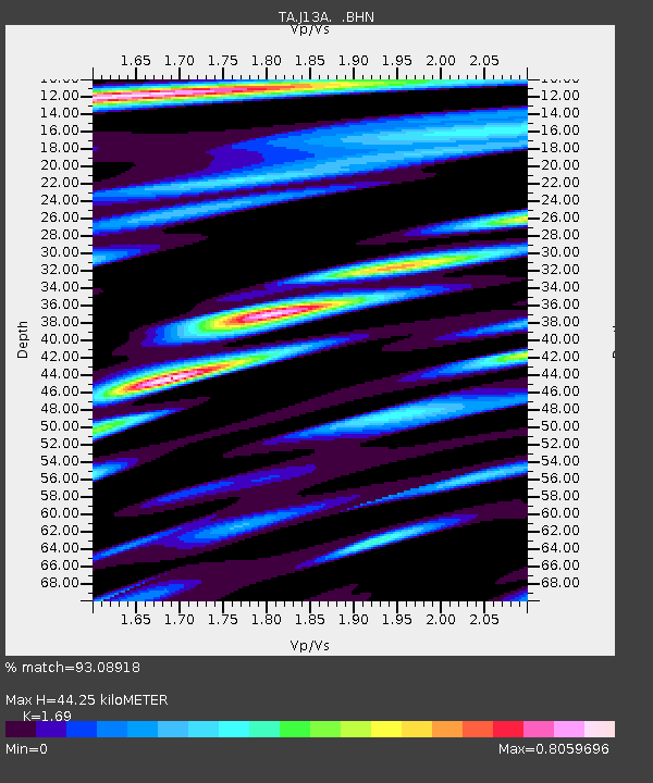
| Estimated Moho Depth: |
44.25 km |
| Estimated Crust Vp/Vs: |
1.69 |
| Assumed Crust Vp: |
6.291 km/s |
| Estimated Crust Vs: |
3.723 km/s |
| Estimated Crust Poisson's Ratio: |
0.23 |
|
| Radial Match: |
93.08918 % |
| Radial Bump: |
400 |
| Transverse Match: |
86.92227 % |
| Transverse Bump: |
400 |
| SOD ConfigId: |
2564 |
| Insert Time: |
2010-03-06 16:01:47.819 +0000 |
| GWidth: |
2.5 |
| Max Bumps: |
400 |
| Tol: |
0.001 |
|
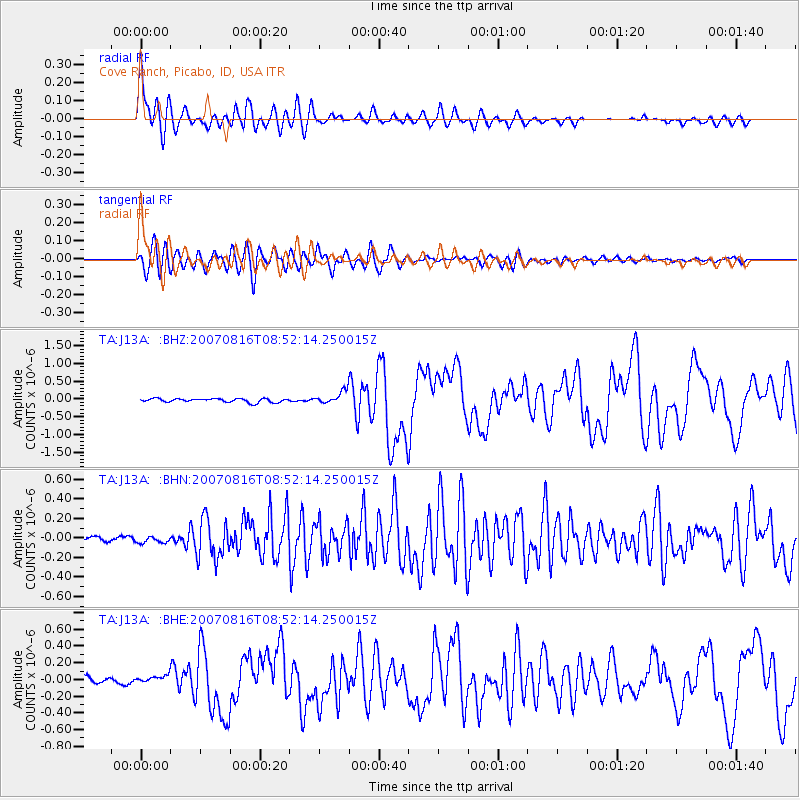
Signal To Noise
| Channel | StoN | STA | LTA |
| TA:J13A: :BHN:20070816T08:52:14.250015Z | 0.6967925 | 3.547559E-8 | 5.0912707E-8 |
| TA:J13A: :BHE:20070816T08:52:14.250015Z | 1.3906739 | 5.9207622E-8 | 4.2574772E-8 |
| TA:J13A: :BHZ:20070816T08:52:14.250015Z | 3.2876222 | 1.735223E-7 | 5.2780486E-8 |
| Arrivals |
| Ps | 5.0 SECOND |
| PpPs | 19 SECOND |
| PsPs/PpSs | 23 SECOND |


