You are here: Home > Network List > TA - USArray Transportable Network (new EarthScope stations) Stations List
> Station J13A Cove Ranch, Picabo, ID, USA > Earthquake Result Viewer
J13A Cove Ranch, Picabo, ID, USA - Earthquake Result Viewer
| Earthquake location: |
Near Coast Of Peru |
| Earthquake latitude/longitude: |
-14.3/-76.1 |
| Earthquake time(UTC): |
2007/08/16 (228) 05:16:56 GMT |
| Earthquake Depth: |
23 km |
| Earthquake Magnitude: |
5.8 MB, 6.1 MS, 6.3 MW, 6.2 ML |
| Earthquake Catalog/Contributor: |
WHDF/NEIC |
|
| Network: |
TA USArray Transportable Network (new EarthScope stations) |
| Station: |
J13A Cove Ranch, Picabo, ID, USA |
| Lat/Lon: |
43.40 N/114.17 W |
| Elevation: |
1552 m |
|
| Distance: |
67.1 deg |
| Az: |
330.82 deg |
| Baz: |
139.572 deg |
| Ray Param: |
0.057129458 |
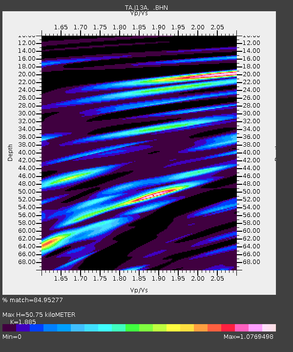
| Estimated Moho Depth: |
50.75 km |
| Estimated Crust Vp/Vs: |
1.88 |
| Assumed Crust Vp: |
6.291 km/s |
| Estimated Crust Vs: |
3.338 km/s |
| Estimated Crust Poisson's Ratio: |
0.30 |
|
| Radial Match: |
84.95277 % |
| Radial Bump: |
400 |
| Transverse Match: |
58.9054 % |
| Transverse Bump: |
400 |
| SOD ConfigId: |
2564 |
| Insert Time: |
2010-03-06 16:01:49.276 +0000 |
| GWidth: |
2.5 |
| Max Bumps: |
400 |
| Tol: |
0.001 |
|

Signal To Noise
| Channel | StoN | STA | LTA |
| TA:J13A: :BHN:20070816T05:27:16.748022Z | 4.043229 | 3.6174816E-7 | 8.947011E-8 |
| TA:J13A: :BHE:20070816T05:27:16.748022Z | 1.0758317 | 1.531985E-7 | 1.4240007E-7 |
| TA:J13A: :BHZ:20070816T05:27:16.748022Z | 3.011638 | 3.6217753E-7 | 1.2025932E-7 |
| Arrivals |
| Ps | 7.4 SECOND |
| PpPs | 22 SECOND |
| PsPs/PpSs | 30 SECOND |


