You are here: Home > Network List > TA - USArray Transportable Network (new EarthScope stations) Stations List
> Station J13A Cove Ranch, Picabo, ID, USA > Earthquake Result Viewer
J13A Cove Ranch, Picabo, ID, USA - Earthquake Result Viewer
| Earthquake location: |
Near Coast Of Peru |
| Earthquake latitude/longitude: |
-13.4/-76.6 |
| Earthquake time(UTC): |
2007/08/15 (227) 23:40:57 GMT |
| Earthquake Depth: |
39 km |
| Earthquake Magnitude: |
6.7 MB, 7.9 MS, 8.0 MW, 7.5 ME |
| Earthquake Catalog/Contributor: |
WHDF/NEIC |
|
| Network: |
TA USArray Transportable Network (new EarthScope stations) |
| Station: |
J13A Cove Ranch, Picabo, ID, USA |
| Lat/Lon: |
43.40 N/114.17 W |
| Elevation: |
1552 m |
|
| Distance: |
66.1 deg |
| Az: |
330.92 deg |
| Baz: |
139.54 deg |
| Ray Param: |
0.057751298 |
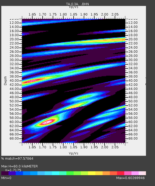
| Estimated Moho Depth: |
60.0 km |
| Estimated Crust Vp/Vs: |
1.72 |
| Assumed Crust Vp: |
6.291 km/s |
| Estimated Crust Vs: |
3.663 km/s |
| Estimated Crust Poisson's Ratio: |
0.24 |
|
| Radial Match: |
97.57864 % |
| Radial Bump: |
292 |
| Transverse Match: |
79.2847 % |
| Transverse Bump: |
400 |
| SOD ConfigId: |
2564 |
| Insert Time: |
2010-03-06 16:01:52.548 +0000 |
| GWidth: |
2.5 |
| Max Bumps: |
400 |
| Tol: |
0.001 |
|
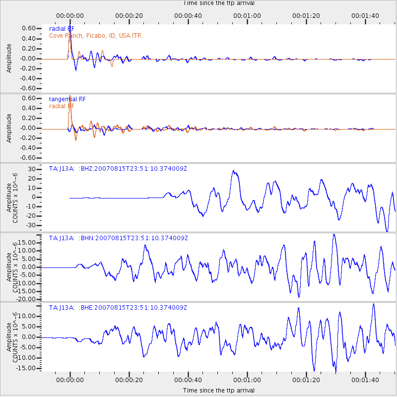
Signal To Noise
| Channel | StoN | STA | LTA |
| TA:J13A: :BHN:20070815T23:51:10.374009Z | 14.393534 | 1.1921575E-6 | 8.28259E-8 |
| TA:J13A: :BHE:20070815T23:51:10.374009Z | 16.135921 | 1.0022578E-6 | 6.211346E-8 |
| TA:J13A: :BHZ:20070815T23:51:10.374009Z | 33.422813 | 3.0063677E-6 | 8.9949566E-8 |
| Arrivals |
| Ps | 7.1 SECOND |
| PpPs | 25 SECOND |
| PsPs/PpSs | 32 SECOND |


