You are here: Home > Network List > TA - USArray Transportable Network (new EarthScope stations) Stations List
> Station J13A Cove Ranch, Picabo, ID, USA > Earthquake Result Viewer
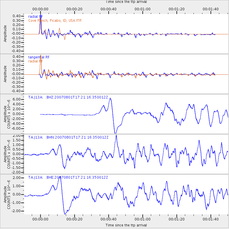
J13A Cove Ranch, Picabo, ID, USA - Earthquake Result Viewer
| Earthquake location: |
Vanuatu Islands |
| Earthquake latitude/longitude: |
-15.6/167.7 |
| Earthquake time(UTC): |
2007/08/01 (213) 17:08:51 GMT |
| Earthquake Depth: |
120 km |
| Earthquake Magnitude: |
6.2 MB, 7.2 MW, 7.2 MW |
| Earthquake Catalog/Contributor: |
WHDF/NEIC |
|
| Network: |
TA USArray Transportable Network (new EarthScope stations) |
| Station: |
J13A Cove Ranch, Picabo, ID, USA |
| Lat/Lon: |
43.40 N/114.17 W |
| Elevation: |
1552 m |
|
| Distance: |
92.2 deg |
| Az: |
45.552 deg |
| Baz: |
250.7 deg |
| Ray Param: |
0.041436125 |
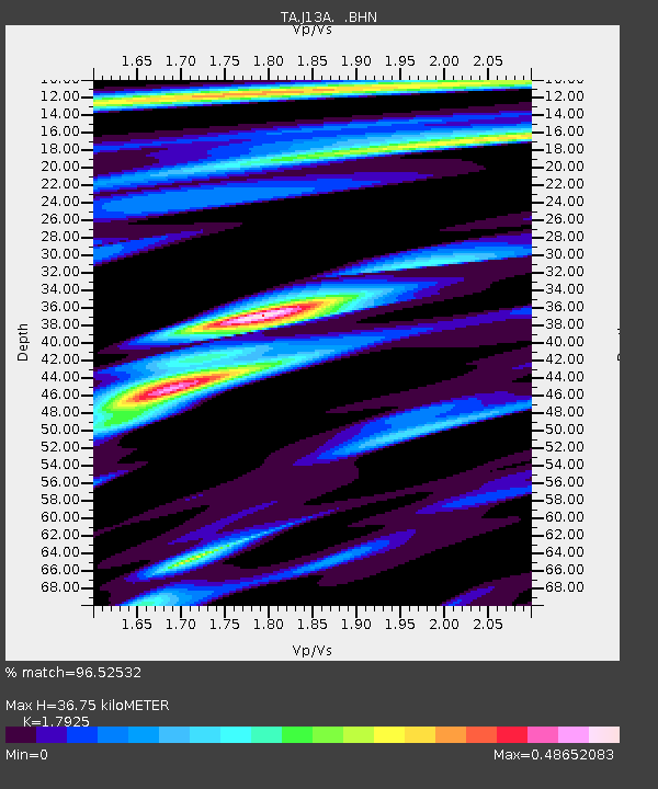
| Estimated Moho Depth: |
36.75 km |
| Estimated Crust Vp/Vs: |
1.79 |
| Assumed Crust Vp: |
6.291 km/s |
| Estimated Crust Vs: |
3.51 km/s |
| Estimated Crust Poisson's Ratio: |
0.27 |
|
| Radial Match: |
96.52532 % |
| Radial Bump: |
400 |
| Transverse Match: |
89.39782 % |
| Transverse Bump: |
400 |
| SOD ConfigId: |
2564 |
| Insert Time: |
2010-03-06 16:02:00.428 +0000 |
| GWidth: |
2.5 |
| Max Bumps: |
400 |
| Tol: |
0.001 |
|
Signal To Noise
| Channel | StoN | STA | LTA |
| TA:J13A: :BHN:20070801T17:21:16.350012Z | 2.1282613 | 8.4578964E-8 | 3.9740872E-8 |
| TA:J13A: :BHE:20070801T17:21:16.350012Z | 1.8811364 | 1.0505968E-7 | 5.5849046E-8 |
| TA:J13A: :BHZ:20070801T17:21:16.350012Z | 3.889686 | 3.7979504E-7 | 9.764157E-8 |
| Arrivals |
| Ps | 4.7 SECOND |
| PpPs | 16 SECOND |
| PsPs/PpSs | 21 SECOND |


