You are here: Home > Network List > TA - USArray Transportable Network (new EarthScope stations) Stations List
> Station J13A Cove Ranch, Picabo, ID, USA > Earthquake Result Viewer
J13A Cove Ranch, Picabo, ID, USA - Earthquake Result Viewer
| Earthquake location: |
Northern Mid-Atlantic Ridge |
| Earthquake latitude/longitude: |
52.4/-31.8 |
| Earthquake time(UTC): |
2007/05/23 (143) 04:41:46 GMT |
| Earthquake Depth: |
10 km |
| Earthquake Magnitude: |
5.6 MS, 5.4 MB, 5.7 MW, 5.6 MW |
| Earthquake Catalog/Contributor: |
WHDF/NEIC |
|
| Network: |
TA USArray Transportable Network (new EarthScope stations) |
| Station: |
J13A Cove Ranch, Picabo, ID, USA |
| Lat/Lon: |
43.40 N/114.17 W |
| Elevation: |
1552 m |
|
| Distance: |
53.1 deg |
| Az: |
295.424 deg |
| Baz: |
49.466 deg |
| Ray Param: |
0.06631339 |
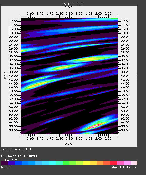
| Estimated Moho Depth: |
65.75 km |
| Estimated Crust Vp/Vs: |
1.98 |
| Assumed Crust Vp: |
6.291 km/s |
| Estimated Crust Vs: |
3.185 km/s |
| Estimated Crust Poisson's Ratio: |
0.33 |
|
| Radial Match: |
84.56104 % |
| Radial Bump: |
400 |
| Transverse Match: |
76.738365 % |
| Transverse Bump: |
400 |
| SOD ConfigId: |
2564 |
| Insert Time: |
2010-03-06 16:02:27.092 +0000 |
| GWidth: |
2.5 |
| Max Bumps: |
400 |
| Tol: |
0.001 |
|

Signal To Noise
| Channel | StoN | STA | LTA |
| TA:J13A: :BHN:20070523T04:50:33.224021Z | 2.6907573 | 1.7719412E-7 | 6.585288E-8 |
| TA:J13A: :BHE:20070523T04:50:33.224021Z | 3.1980658 | 1.9300404E-7 | 6.035024E-8 |
| TA:J13A: :BHZ:20070523T04:50:33.224021Z | 8.217459 | 5.950087E-7 | 7.240787E-8 |
| Arrivals |
| Ps | 11 SECOND |
| PpPs | 30 SECOND |
| PsPs/PpSs | 40 SECOND |


