You are here: Home > Network List > TA - USArray Transportable Network (new EarthScope stations) Stations List
> Station E20K Nigu River, AK, USA > Earthquake Result Viewer
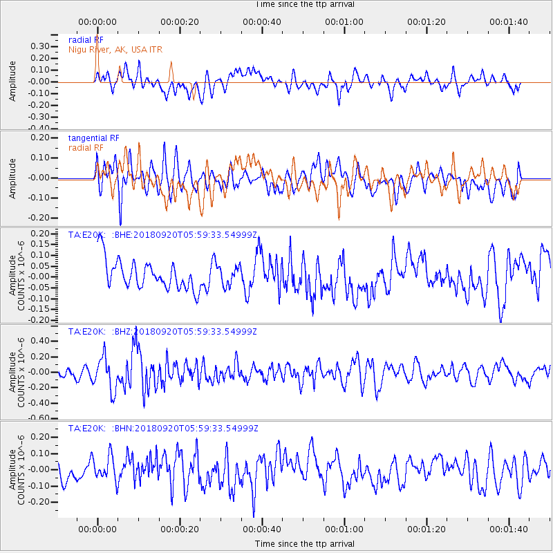
E20K Nigu River, AK, USA - Earthquake Result Viewer
*The percent match for this event was below the threshold and hence no stack was calculated.
| Earthquake location: |
Solomon Islands |
| Earthquake latitude/longitude: |
-9.0/158.3 |
| Earthquake time(UTC): |
2018/09/20 (263) 05:47:37 GMT |
| Earthquake Depth: |
10 km |
| Earthquake Magnitude: |
5.5 mb |
| Earthquake Catalog/Contributor: |
NEIC PDE/us |
|
| Network: |
TA USArray Transportable Network (new EarthScope stations) |
| Station: |
E20K Nigu River, AK, USA |
| Lat/Lon: |
68.26 N/156.19 W |
| Elevation: |
866 m |
|
| Distance: |
83.5 deg |
| Az: |
15.514 deg |
| Baz: |
225.167 deg |
| Ray Param: |
$rayparam |
*The percent match for this event was below the threshold and hence was not used in the summary stack. |
|
| Radial Match: |
43.44458 % |
| Radial Bump: |
400 |
| Transverse Match: |
62.753845 % |
| Transverse Bump: |
400 |
| SOD ConfigId: |
13570011 |
| Insert Time: |
2019-05-01 07:05:48.608 +0000 |
| GWidth: |
2.5 |
| Max Bumps: |
400 |
| Tol: |
0.001 |
|
Signal To Noise
| Channel | StoN | STA | LTA |
| TA:E20K: :BHZ:20180920T05:59:33.54999Z | 2.9791055 | 2.1828683E-7 | 7.327261E-8 |
| TA:E20K: :BHN:20180920T05:59:33.54999Z | 1.2978262 | 8.046557E-8 | 6.200026E-8 |
| TA:E20K: :BHE:20180920T05:59:33.54999Z | 0.61109626 | 4.2078106E-8 | 6.885676E-8 |
| Arrivals |
| Ps | |
| PpPs | |
| PsPs/PpSs | |


